| Daily |
2004-7-1 | mH |
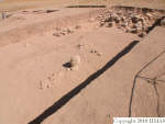
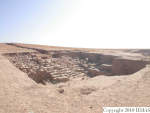
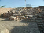
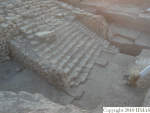
Opened the square and had time to remove just the upper most surface layer in the eastern half of the square.
|
|
2004-7-4 | mH |
We continued removing topsoil in the western side of the unit. After a while I changed the feature into f23, which consists of the same variation of soft and hard soil as in all the other units. At the end of the day we broke the soil also in the eastern side of the unit. That did not produce any pottery during the short time we worked on it today.
|
|
2004-7-5 | mH |
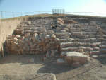
We reached roughly the level of k4, k5 and k14 in the western half of the unit so I stopped the excavation there and started going down in the eastern half. In the eastern half, however, we found two large stones: one was in the NW corner of the unit and one near the southern baulk. These stone are not only higher than the apron stones in the German trench that runs through k13, they are also higher than the stone features f24, f26, and f27 in k5, k14 and k4 respectively. It appears that they have eroded down from the temple terrace to the north. In the eastern half of the unit we started from topsoil feature f29 and after awhile continued with f30. This is latter material is similar to what we have found in other units: natural accumulation with patches of harder and softer soil.
|
|
2004-7-6 | mH |
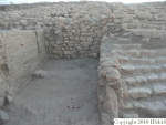
We started the day with f30, which consists of the same natural soil matrix as everywhere else, i.e. patches of hard and soft soil. Towards the end of the day I changed the feature into f31. Originally I defined it as ly since it does not differ from the soil above it. I did the division arbitrarily in order to make it easier to separate q-lots. After one pickful we found a large stone near the northern baulk of the unit. Since this stone is probably a part of the stone apron flanking the temple steps, I decided to define the feature as ld, accumulation associated with the stones.
|
|
2004-7-7 | aP |
here we cleaned a small portion of the square in the north-western corner ( q71). The soil is very soft.
|
|
2004-7-11 | aP |
we decided to go down in the eastern part of the square which is cut from north to south by the German trench ( f31, q103). The goal for today was to reach the level of the western part of the square. We draw the eastern section of k13 which below the top soil presents two very homogeneous features.
|
|
2004-7-12 | aP |
we removed the eastern baulk of k13 ( f56, q119 and q122).
|
|
2004-7-24 | aP |
we went on removing the columns of soils on which the eroded stones were placed ( f91, q242) and removing soil in the western of the square ( f41, q245).
|
|
2004-7-24 | mH |
Continued in two locations: 1) close to the western edge ( q245) and 2) at/around the northwest corner. At the northern edge of k13 the stones end abruptly. About 50 cm south there is, however, an east-west line of stones. We do yet know if these stones continue towards south since we have not excavated there yet.
|
|
2004-7-25 | aP |
we are going on in the southern part of the square where there are not stones. In a first time we finished to remove the columns of soil which were below the stones remove by the crane ( f91, q246) and after we reached a new feature ( f95, q255). This feature is different for texture and colour. The colour is brownish and the consistency quite soft. In the south-eastern corner we found remains of the plastic so it appears clear that this part of the square was already dug by the Germans.
|
|
2004-7-26 | aP |
we continued to go down ( f95, q266) until we reached a new layer. This feature ( f103) is characterized by a very compact soil with dark brown colour. It's clearly different from the layer above which was moved by the German during the excavations. It's probable that the top of f103 was used as walking plan. We collected the following q-lots ( q266, q270 and q278).
|
|
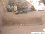
2004-7-27 | aP |
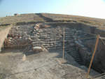
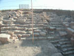
we continued going down in the southern part of the square, cleaning the wall which is starting to be visible. The feature is always the same ( f103), with a soil very hard and compact. We removed q288 and q305. In the same unit we started to remove the eastern baulk ( f116, q310).
|
|
2004-7-28 | aP |
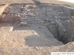
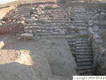
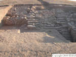
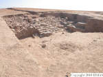
in this unit today we started going down for about 20 cm in all the surface which is possible digging ( f103, q320 and q335). After we numbered and removed all the collapsed stones in the square. Unfortunately we did not take the picture of the stones before the removal. We decided to remove the columns of soil according a stratigraphic methodology, not giving a new number of feature for the column. In fact we want to flag the pottery found below the stones to date the collapsing of the stones. For this reason just below the stones we dug f103, q329 and after f 103 ( q332, q335) removing hard and very compact soil, with graysh colour. At the meantime we are digging the eastern baulk with the small pick (Kamiran and Samir) to see better the consistence of the layer which was removed with big pick. The layer is really very compact and seems that the upper surface was used as walking surface. The eastern baulk of k13 is f116 ( q321, q333, q334).
|
|
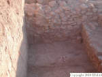
2005-8-3 | mH |
We started by removing a small area of soil that was left from yesterday's pit run ( q369). After this fAB brough aL and pC to practice small picking in the southeast corner of k13 just above stones that are emerging from the soil. aL discovered patches where there was plenty of pottery sherds all aligned horizontally. We determined that this area was a walking floor and defined it as f142. On the floor we found a decorated Khabur sherd q373.3 in situ. We took photos of this floor and the sherd. These are represented in v76. After the photos we tried to see whether the floor continued towards west by removing a few centimeters at a time with a small pick. The floor did not continue and thus we continued with the big pick. This area was removed as f140 q379.
|
|
2005-8-4 | mH |
We continued going down in k13, but just with one q lot ( q382).
|
|
2005-8-6 | mH |
We placed the third elevator into this unit and it now prevents us from going down in it. We opted for this placement at least for now, since we have plenty of work to do both in k100 and k4 and we only have men for two operations at a time. Before placing the elevator into the unit, however, we placed a plasting on our excavation surface and collapsed some dirt from the top of the western section of this unit where there had been a large and dangerous-looking crack.
|
|
2005-8-7 | mH |
We did not excavated here today since the elevator is located in this unit.
|
|
2005-8-8 | sC |
Today we dug the north-east area of k13 where we finished removing f142. f142 was assigned last week and was not completely excavated because the elevator was located in the middle of the square; the area in which f142 was still in place was aproximately 2m NE and 2m S. One qlot was collected during the exavation of f142 ( q404). Once reached the bottom of f142 we moved the workmen in k14.
|
|
2005-8-9 | mH |
We did not excavate here today, but the baulk markers bP put in today made it clear that some part of the unit we have been calling k13 is actually the north baulk of k14 and some of that area even falls into the last 1 m of the 4x4 of k14. With the new baulk markers this will no longer be a problem.
|
|
2005-8-13 | mH |
Once we had removed the elevator into k14, we cleaned the area well and started excavating in the 2x2 m area that is left from k13 in front of the oval wall ( f128) when k101 is excluded. We continued with the feature we had assigned this locus earlier ( f140), but noted that the first q-lot excavated ( q439) has been contaminated by the soil that ended up here when the elevator was located in this unit. While cleaning up after this q-lot we collected a seed sample ( q439.1) close to the border between k101 and k13, right next to the oval wall. The next q-lot was q443. Both q-lots contained pieces of gypsum in the soil along the oval wall and f127. We finished the day by excavating the southern half of the unit ( q447).
|
|
2005-8-14 | mH |
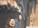
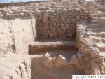
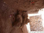
We started by removing the northern half of the unit ( q450). After excavating this and cleaning the surface we noticed that the soil changed color. It became clearly browner, it had small pebbles, gypsum, ash and charcoal as inclusions. We labelled this feature as f171. After excavating the first qlot ( q455) within this feature, we noticed that the ash and charcoal concentrations became more pronounced and there was more of it. We also found a stone close to the SE corner of the excavation area. And, in the spaced formed by the stone and the corner of walls f128 and f127, we found a deposit of pot sherds positioned vertically rather than lying flat horizontally. They also seemed to form a circle. These aspects of the deposit made us suspect that this might be one complete pot. We thus gave these sherds its own q-lot number ( q461). We marked this qlot for mKB to take a look at. At her suggestion we also marked the q-lot above this ( q455) for her because it might contain pieces belonging to the possible pot. q-lot q455 also produced a sealing q455.1. This sealing was uncovered very soon after seal impression q458.1 was discovered in k101. Until this point we had had a large floating stone right in the middle of the unit. We relayed it and gave it a feature number ( f175), and after breakfast we took a picture of it in situ ( v85), the ash deposit south of the stone in the NE corner ( v85a) and the possible pot in the corner ( v85b). After removing the stone ( f175) and the pedestal on which it rested ( f176), we took another picture of the whole unit ( v85c). The pedestal contained a layer of ash and charcoal. Its elevation was m3965 +112 -147 = 89.26m. During the removal of qlot q455 and especially qlot q462, the latter of which followed the removal of the floating stone ( f175), we found several tannur pieces although we did not recover a tannur in situ. At the end of the day, after removing q462 a heavy concentration of ash, charcoal and organic matter was exposed to south of the stone and abutting f127. We also found a door socket stone.
|
|
2005-8-15 | mH |
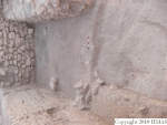
We continued excavating in f171, which contains heavy and discreet concentrations of ash. At the start of the day, the ash was concentrated mainly south of the stone and next to f127 ( v86c). At the end of the day we found a heavy ash concentration more towards the middle of the unit ( v87d and v87e). In the morning we also took a picture of the doorsocket ( i9, v86b) before removing it and starting to excavate q480 with a small pick. Near the wall the deposit was harder but it consisted of the same material as the rest of the unit. The ash concentrations were very strong and quite large, and it and the deposition around it have very distinct colors ranging from very pale grey/ash white to strong brown (7.5YR5/6), very dark grayish brown (10YR3/2), light brownish gray (10YR6/2), and yellowish brown (10YR5/4). We continued excavating with a small pick still in search of a possible floor surface ( q487), but did not find one. After q487 we switched into a big pick and continued down ( q491). Below the this last qlot we found yet another large ash concentration this time located more in the center of the unit ( v87d and v87e). This ash concentration forms a semicircal around an area where there is not ash, but there is a animal hole in the middle of this. This animal hole influences q-lots q487 and q491.
|
|
2005-8-16 | mH |
At the start of the morning gB came to take a look at the area formed by k101 and k13 and shown in v87. The elevation this plane in k13 is m3965+42-138 = 88.65 m, i.e. the same elevation where f150 in k4 is currently and where samples q397, q398, and q399 were taken. He was of the opinion that we are definitely excavating in a use area. He told us to continue excavating with a big pick but paying attention to possible surfaces. At this point we had been excavating in f171 for 30 cm and thus we decided to change the feature ( f183) although the brown soil with ash concentrations seemed to continue. Right at the start of the excavation of the next pick run ( f183 q496) we ran into what seems to be a pebble and sherd pavement or floor just south of the stone and next to f127. At the sight of this we decided just to remove the dirt that Kamiran had loosened and not excavate further. At this point we do not know whether the pavement/floor continues beyond the exposed area of approximately 40x30cm. At this point we were at 88.47m, i.e. 20cm lower than the current surface of f150 in k4.
|
|
2005-8-24 | sC |
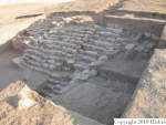
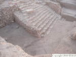
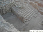
After having string and took the relay for define k101 (the pottery column) and therefore k13, Kamiran start to dig in k13. I checked the area and assigned two features numbers: f227 to the layer of pottery sherds lying in a horizontal way in the north-east corner of k13 (aproximately 40cm W from r713 and 35cm S from r713, at the absolute elevation of 88.45) and f229, that interests the remaining portion of the area. The q580, that contains pottery collected from the first 10 cm from the excavation of this feature ( f229), could have been contaminated by the excavation in k14 from the previous days. f229 present the same characteristics of f228 (in k101): the soil has a very fine and soft texture; one little area with ashes interests the central area of k13. After a pickrun of aproximately 5-10cm of f229 a very compact and well defined surface have been exposed, which have been labeled f231. f231 is probably a floor surface characterized by a very compact surface with a fine texture and slopes a bit toward the southern part of k13; once excavated, is very soft and friable in consistence. In same part of the area we noticed also some ash lenses. Two animal holes ( f250 and f251) intrude f231, on the south and central area of k13. Both have a diameter of 9-11cm and one of the them was fill with a very soft soil texture. fAB helped me to explain to the workmen that they must keep trace of these two animal holes while excavating (boths continue under feature f231) and therefore remove firstly the soil contained in these holes in order to avoid any contamination in the lower features. With the excavation of f229, f227 (the pottery layer) is cleary localized only in the the north-eastern corner of k13; f227 abuts f231, and f231 is the same of f234 in k101. From the excavation of this feature ( f227) it has been collected a large amount of pottery (qlo t588, qlo t591). After having took a picture (g v102, g v102a) we started to remove f231.
|
| Strategy |
2004-7-4 | mH |
We will continue with both sides of the unit tomorrow.
|
|
2004-7-6 | mH |
Tomorrow we will continue down to the level of k4, k5, and k14 and of course leave any stones we find pedestalled.
|
|
2005-8-16 | mH |
Once gB heard that we had exposed a pavement/floor surface he suggested that we should aim for a large horizontal exposure of the use area formed by f150 in k4, f171 and f183 in k13, and f174 and f182 in k101. This necessitates going down in k14, in the southern part of k4, and north baulk of k5. Thus stopped excavating in k13 and k101, and moved the team to k14.
|
| Argument |
2005-8-14 | mH |
Tannur pieces, ash, charcoal, and bone found in f171 suggest that this feature has something to do with kitchen/cooking activities. At first we thought that this feature would relate to f150 located in k4, but f150 is still 30cm lower than the elvation we are at currently in k13.
|
|
2005-8-15 | mH |
Excavation here progressed very slowly because we were excavating mostly with small pick. I chose this approach because I suspected that we might be near some sort of a floor as this feature must be a use area. The tannur fragments, ash, charcoal, bone, and also the doorsocket suggest such an interpretation.
|