Overview

Overview of Unit J4

May 2010 - S. Comelli
The home for this page is J4

Physiognomy
Location
Background
Goals
Beginning of excavations
Progress of excavations
End of excavations as of 2002
Main results
Phases
General statistics

Physiognomy

     [THIS SECTION ADDED] J4 was started as a test excavation aimed at clarifying what we expected to be a specular situation of the Temple Terrace monumental staircase. As it turned out, this was to be a seminal excavation that instead higlighted, for the first time, a great propensity for asymmetry in Urkesh architecture. This led the way for the subsequent excavations in J6, which expanded considerably the scope in a lateral direction, both to the south and to the north.
     Excavations in J4 also confirmed the same direct superposition of strata separated by a gap of more than one thousand years that we had already seen in J1 and J2. The excavation carried out in J4 started from the topsoil (Phase h8-JPA) and exposed Late and Middle Mittani layers; furthermore, in a deep sounding within locus k100 a 3rd millennium BC layer was unearthed right below Mittani layers.
Back to top

Location

     Unit J4 is located east of J2, where the 'monumental access' to the temple terrace (represented by the Primary Apron) and a stone staircase (rispectively features J2f130 and J2f131) were exposed during the 2002-4 excavation seasons.
     It incorporated a trench (T14) excavated as part of B6.
     J4 was in turn incorporated within J6, begun as a unit south of J4. This happened when it became clear that the architectural layout we anticipated when J4 was started did not materialize, and that the southern extension would best be seen together with the area to the north, where J4 was located.
;FARE TEMPLATE 105 PER MOSTRARE AREA PRIMA DELLO SCAVO
Back to top

Background

     The stone staircase was partially exposed during the investigations carried out in 2001 in this portion of the terrace mound by a team of the university of Tübingen (directed by Peter Pfälzner). Their operation in this sector was labeled B6. In light of this recovery, in the 2002 excavation season, Unit J2 was set west and around the portion of the stone staircase, which lead to the exposure of an extended stone structure. The staircase proper was labeled J2f130, while the stepped structure to the west, defined as the main Apron, was labeled J2f131 and J2f132. The excavations in J2 also exposed a portion of a wall (J2f129) flanking the staircase to the east.
     One of the 'German' trenches, T14 (a 10m trench with a W-E alignment) exposed portions of a stone structure located approximately 9 meters east of wall J2f129, which, in light of the excavations carried out in J2 during the 2004-5 season, was thought to be part of a (possible) western Apron, assuming a specular arrangement of the monumental staircase complex.
     It was to test the possibility of such a specular arrangement that it was decided to open Unit J4.


Back to top

Goals

     In the 2006 excavation season, J4 has been set immediatly east to J2 Unit with the following aims: understand whether the secondary Apron as exposed in J2 area continued on the east, and, in this case, determine its extension), thus determining if f10 was part of it, or whether the area east to the monumental staircase could have been the eastern limit of the 'monumental access' to the temple terrace. A more general aim was to understand the activities that were carried out in the area east to the 'monumental staircase'. For this reason, J4 Unit was initially set around f10, the stone structure exposed by the 'German' trench T14.
Back to top

Beginning of excavations

      Initially set in the north portion of the tell mound, around the stone structure, f10 (k80,k71-k72-k61-k62), J4 area expanded later toward south (k73-k74,k63-k64,k82,k83-k84,k100).
     The area was subdivided in 13 loci, being generally 5x5m square each (besides few of them, which were smaller in size, as for example, k84 and k70). Few of these loci had been already investigated previously; k82 and k83 in season 2004-5 as part of J2 Unit, while k80, k71 and k73 were only partially investigated, since they has been cut by a W-E trench (rispectively T15, T14 and T10) dug in 2001 excavation season by a team of the university of Tübingen directed by Prof. P. Pfälzner during a sounding in this portion of the tell mound.
Back to top

Progress of excavations

     The excavation started from the topsoil and then interested a thick layer natural accumulations (soil blown and wind and water-born in nature) which contributed to the build-up of the tell surface for aprox. 2 meter in deep (related with Phase 85-MZA and Phase 67-MZA). The build-up due to the natural accumulations is visibile in the long N-S section of tJ4 area as visible in v32 and related subviews, which shows how the soil matrix that form the build-up of the tell mound for aPproximately two meter is the same. Within the lower meter of accumulations lots of pottery sherds have been collected (which date these layers to Phase 67-MZA), however, in spite of the pottery sherds recovered, there are no evidence of active use or human activity within J4 area in Phases h85-MZA and h67-MZA (Late Mittani period), as it is cleary visible from v32 and related subviews (no structures have been exposed within the whole area, besides f10, which was already exposed since the beginning of the excavation).
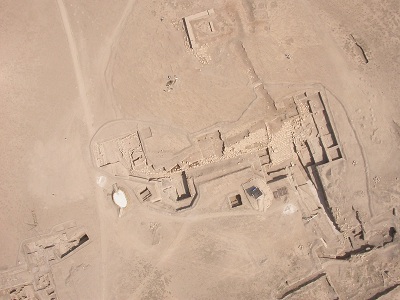
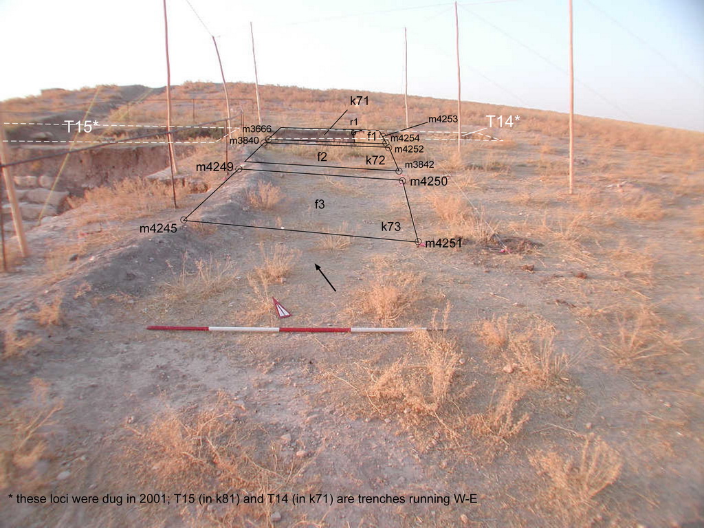
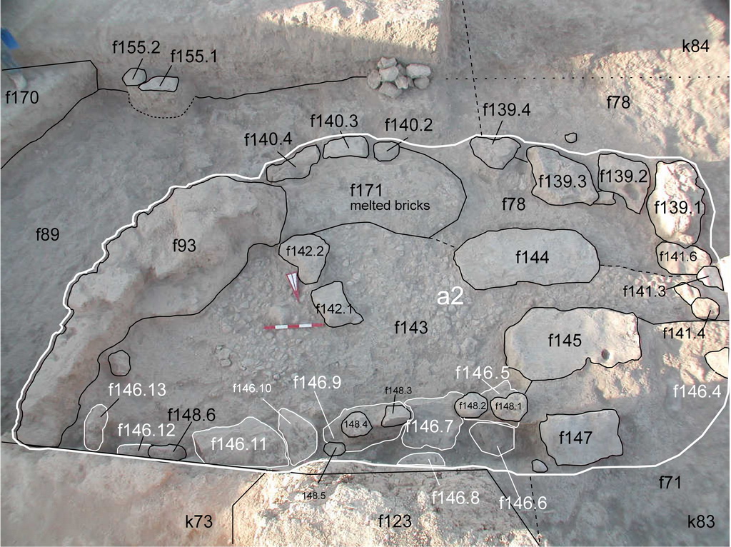
     v61 show the area after aprox. 2 weeks excavation. This view shows the mud-brick and stone structures that were in use in Phase 65-MZA (dated to the Middle Mittani Period), a period in which major rebuilding in different portion of the temple mound, as we know from J2 and J5 areas. It is however unclear the exact function of the various mud-brick and stone structures, since, we exposed in most of the cases only the top-face of these structures, which are concentrated in few loci (k71- k73, k62). We assume that these were related with activities connected with the temple area.
     The excavations however, did not clarify one of the goals set for this excavation season, which was understand the nature of f10. Before the beginning of the excavation it was expected to expose in J4 the secondary Apron and, perhaps a staircase or portion of a staircase, since we were thinking in the possibility of finding in J4 a specular structure to J2, given f10, the alligned stones in k71, besides of the difference elevation with the stones in J2 Unit. At the end of the excavation season we just cleared that f10 does not belong to a a possible secondary Apron, and we leave the question on the nature of this stone structure open to further investigation. the goal of the excavation season was to find the continuation of f10 south or to the east and understand its nature and explore if any activities took place within this portion of the tell mound. However, a unexpected find while carrying out the sounding in k100, opened new questions on the stratigraphy of J4 area and of this portion of the tell mound, that was left open for further investigation: clarify and better understand the presence of 3rd millennium BC levels and cleary located directly below Mittani accumulations. This question, however, has been fully cleared with the excavation carried out in Unit J6 in the last two excavation seasons, where layers dated to the end of the 3rd millennium BC were exposed directly below Mittani accumulations (cfr. J6 Phase h32 and h33-MZA in J6 k84 and J6 k85).


Back to top

End of excavations as of 2002

     The excavations in J4 area ended on September 18, 2006. v73c and v74 show J4 area at the end of the excavation season. [FOLLOWING SENTENCE IS TOO LONG AND UNCLEAR.] This view shows the glacis layer f127 exposed in the north portion of the J4 Unit, in loci k82 and k72 (relative to phase h63-MZA dated to the Early Mittani period), the Middile Mittani structures concentrated in the central portion of the area (a2 and related features), and k100, where we did a deep sounding where a 3rd millennium BC layer was exposed right below Middile Mittani accumulations.
     The stratigraphy found here is to J6 Unit, where 3rd millennium BC levels located directly below Mittani layers (cfr J6 Phase 32-MZA) have been exposed in the last two excavation seasons.

Back to top

Main results

     The main results of the 2006 season may be summarized as follows.
  1. f10 does not belong to a a possible secondary Apron, as thought before start the exacavtions, and the question on the nature of this stone structure is open to further investigation.
  2. Below the topsoil layer and layers related with the tell surface and erosion there is a sequence of Mittani layers, and, thus, this portion of the tell mound seems not [THE WAY YOU STATE IT HERE, IT DOES NOT FOLLOW - SHOULD REPHRASE] to be in use until the Late-Middle Mittani period.
  3. Early Mittani levels were reached in a deep sounding in k100 (these are related with Phase 63-MZA) which were located directly on top of a third millennium BC layer (cfr. Phase 33-MZA), situation found as well in J6 area during the last two excavation seasons (2008-9), and Previously, in J2 area (2004-5).
  4. A glacis layer covering the area East to wall J2f129 (which could be seen as the eastern boundary of the 'monumental staircase'(J2f130) and of the monumental complex as exposed in J2 (that we defined as the secondary Apron, J2f131 and J2f132)
  5. The nature and function of two stone walls (f84 and f157) located at a higer elevation respect to the structures remains unclear.
  6. THE SINGLE WELL DEFINED STRUCTURE FOUND WAS THE BIN
  7. OBJECTS: THE PLAQUE q16.1
  8. FAUNAL REMAINS: THE SELUKI i5


Back to top

Phases

     The stratigraphy of J4 is similar to J2 and J6 units; it is in J6 area that in the last two excavation season was found a similar stratigrapical situation, i.e.,: 3rd millennium BC levels were found directly below Mittani layers (cfr J6 Phase h33 and h32-MZA).
The excavation carried out in Unit J4 allow to define the following Phases:

Phase h8-JPA is related with the activities that took place in modern times. This Phase is represented by the trenches dug in the Tell terrace in 2001 during a investigation of this portion of the tell mound.

Phase 85-MZA: this Phase is related with the upper layers, such as the topsoil and the accumulations below the toposil which are washed or eroded layers and natural accumulations that build-up the tell surface for aproximately 1 meter.

Phase 67-MZA: similar to Phase 85-MZA, since Phase 67-MZA is as well related with the build-up of the tell surface due to natural accumulations; Phase 67-MZA is represented by thick layer of natural accumulations that build up the area for aproximately another meter. Phase 67-MZA is dated to the Late Mittani Period.

Phase 65-MZA: The excavations carried out in J4 area indicate that some activities start to took place in Phase 65-MZA which is a period in which major rebuilding in different areas of the temple mound (as we know from J2 and J5 areas) and is dated to the Late-Middle Mittani Period. In J4 area, this 'rebuilding phase' is represented by different mud-brick and stone structures, concentrated mainly in few loci (k71- k73, k62). Within this Phase a dump took place in the whole J6 area (cfr. J6 dump^1), which interested the southern portion of J4 area as well.

Phase 63-MZA: This phase has been attributed, on the basis of the excavation carried out in the tell terrace, to the Early Mittani period. This period concerns a re-organization of the area around the so called 'monumental staircase'. As part of this re-organization of the space East of wall J2 f129, a series of glacis layers were placed on top of the tell mound and large stones were placed on top of the glacis layers. Concerning J4, there are no structures in use in this Phase; the only activities that tool place within this Phase are related with a glacis floor surface in two loci.

Phase 32-MZA: is represented, in J4 area by two features dug in k100. In this locus we did a deep sounding at the end of the excavation season where we exposed a 3rd millennium BC layer right below Mittani accumulations. The stratigraphy here found is similar to J6 Unit: also in this area a similar stratigrapical situation was found, and 3rd millennium BC levels were exposed directly below Mittani layers (cfr J6 Phase 32-MZA) in the last two excavation seasons.

Back to top

General statistics

     One will find here some of the major figures relating to the J4 books. More details will be found in the data set section.
approximate cubic meters
total number of features
total number of items
total number of q-lots
total number of sherds
total number of output files
total number of records
total number of hyperlinks
total number of photographs
total number of drawings [not processed in this version]
total file size (with low resolution graphic files)
Back to top