Geography
Syro-Mesopotamia
relief and water use
climate
roads
Back to Urkesh Overview
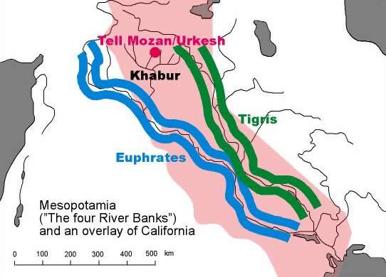
Syro-MesopotamiaThe geographical area that served as the stage on which the history of Syro-Mesopotamia unfolded was about the size of California (its outline is shown here in pink).The environment in which it developed is defined by a number of geographical factors that are here briefly described. The main factor are the two rivers, not so much because of the region contained "between" them (as the Greek term "Mesopotamia" implies), but because of the fertile plains on either side of their banks. Hence the ancient term "Land of the Four River Banks" which (arguably) may be considered as the Mesopotamian term for Mesopotamia. Back to top |
|
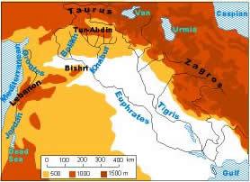
relief and water useThe region where Urkesh is located is defined in the first place by mountain ranges and rivers. The Taurus and the Zagros form a vast arc that delimits to the north and the east what we also know as the “Fertile Crescent.” From them flow the two great rivers, the Euphrates and the Tigris, with their tributaries – of which the most important for us is the Khabur.The Mediterranean and the Gulf are known in the ancient texts as the Upper and the Lower Seas, viewed as upstream and downstream in relationship to the great rivers. Back to top |
|
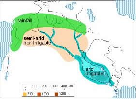
climateThree major climatic regions can be differentiated. To the north there is sufficient rainfall to support a stable agriculture (this is called a “dry-farming” environment). It is in this zone that Urkesh is located. In the central zone, the rivers have cut a fairly deep canyon: irrigation is possible only in this narrow corridor of the valley floor, whereas the higher grounds consists of a steppe with a minimum of ground cover that is however sufficient for herd grazing.To the south, where the rest of urban culture developed, rainfall was insufficient, and one had torely on irrigation. This is possible on a large scale only in the extreme south, where there is a totally flat landscape that allows the construction of an extensive canal network. Back to top |
|
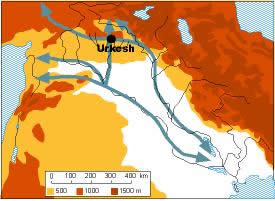
roadsThe rivers served as a major avenue for trade, but so did the plains – wherever there were urban centers that provided services and guaranteed security. Urkesh was located at a pivotal point in this communication network. It was a hub for the noth-south road coming from the Anatolian plateau and for the east-west road linking the Mediterranean and the Zagros.It served as a veritable gateway to the mountain area from which many resources (especially copper) came to the great cities of the south. The great pass where the modern city of Mardin is located, so clearly visible from our site, is emblematic of this ancient situation. Hence the source of its wealth. Back to top |
|