Back to top: Area AA: an overview
Definition of Area AA
|
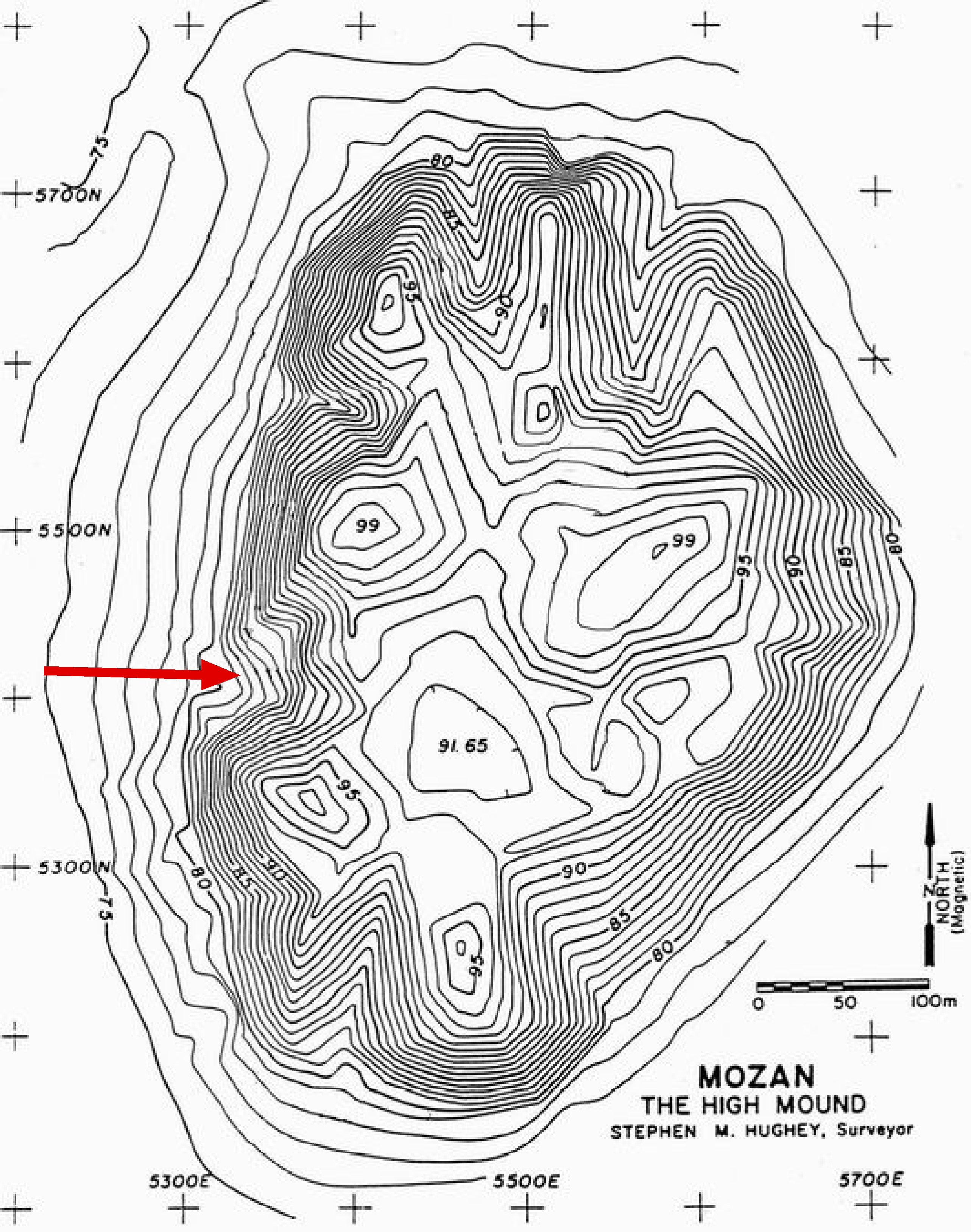
In 1990 we decided to open a step trench for we which had two main goals in mind. The first was to obtain a stratigraphic sequence from the highest point on the mound, but one that would not cut through the inner city wall. We had already exposed the city wall in Area KW (tin the eastern part of the mound) and we felt that the step trench would be more informative if it would expose an area representative of the normal occupational sequence, i.e., one without the singular features associated with the city wall. The second aim was to obtain as extensive a lateral exposure as possible near the base of the High Mound, where we might expect to find substantial strata of the more ancient horizons in the occupational history of the ancient city. The best spot on the mound where we could achieve both of these goals was in Zone A. As the site plan shows, this is the only place where there is a widening at the base. Elsewhere, the profile of the mound is steep – resulting from the presence of the inner city-wall which, once its function as a defensive system was lost, became like a girdle that held the strata within the city in place, and provided the evolving mound with a steep edge all around. |
 |
|
Back to top: Area AA: an overview
History of excavations
|
Already during the first season (1990, the sixth season of our work at Mozan), it became apparent that the lowermost squares of the step trench contained an important building, with large rooms and significant accumulations above the floors. This unit was called A1. The higher units of the step trench were called A2 through A4. After a study season in 1991, it was decided to expand the excavations in this lowermost portion of the step trench, and from that point on lateral exposure of the building (which turned out to be the Palace) became the main goal. The expansion of the excavations followed our growing understanding of both the Palace and the settlements above it. |
 |
| Following are the dates when the new units were opened, with the number of the season and the main goal as we perceived it at the time: |
| 1990 | 6 | A1, A2, A3, A4: step trench |
| 1992 | 7 | A5: expansion to west |
| A6: expansion to east | ||
| 1993 | 8 | A7: expansion to the northwest |
| 1996 | 9 | A8: a small operation to probe the higher levels |
| 1997 | 10 | A9: the northern courtyard |
| A10: the southeast corner of the building | ||
| 1999 | 12 | A11: lateral exposure of the settlements to the northeast |
| A12: expansion to the southeast of the building | ||
| A13: the southwestern portion of the formal wing | ||
| 2001 | 14 | A14: access to the ābi (= A12) |
| A15, A16: expansion to the east | ||
| 2003 | 16 | A17, A18: further expansion to the east |
| A19: search for the eastern limit of the Palace |
|
The area covered by A12 started out as A10. Once it became clear that the new area had a clear definition wholly separate from the Palace (in particular the structure which turned out to be the ābi) the new label A12 was assigned to it. Both A10 and A12 include in turn portions of the formal wing of the Palace, which was then subsumed under A13. Unit A19 was excavated in 2003 as J1 west, because it was conceived as a single unit with J1 east (they were originally intended to form a single row of squares). Once the very different nature of J1 west and J1 east was understood, it became apparent that J1 west belonged with the AA area, and thus it was renamed A19. In 2005 and 2006 we did not continue excavations in AA in order to concentrate on the eastern end of the monumental urban complex. We plan to resume excavations in portions of AA in 2007. |
Back to top: Area AA: an overview
Areas within Area AA
|
Given the considerable size and stratigraphic complexity of Area AA, a number of subareas have been defined within its boundaries. They are listed below (the lables match the sequence in the photograph, from the bottom up). Note that while these areas match to some extent the different chronological phases, they are in fact spatial categories, reflecting coherent typological wholes with different usages at different points in time. |
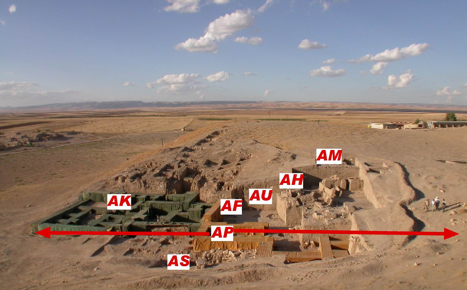 |
| AS | The lower sacral area, partly excavated (A12, A14). It includes the underground necromantic structure (the ābi), the platform against the southern wall of the Palace, and the open area to the west of the ābi that provided access to it. The lower sacral area remained in use for seemingly the same purpose even after the Palace was abandoned, until the Khabur and possibly the Mittani period. (At the beginning of the excavations in 1990, the label AS was used to refer to the step trench, but this label was not effectively used in any portion of the record.) |
| AP | The full extent of the Palace, which contains in turn AK and AF. The Palace was used during phases 2 and 3. |
| AK | The service wing of the Palace: (in green in the photo) it was originally understood as a royal storehouse, and it has now been almost completely excavated (A1, A5, A6, A7, A9, A10). The courtyard to the north would seem to belong to AK, but this will not be clear until further excavations will show whether the service wing continues to the north of the courtyard, or whether the courtyard is flanked to the north by the formal wing (as it is to the east). |
| AF | The formal wing of the Palace (in yellow in the photo): only a small portion has been excavated (A13, A16, A17, A18). It extends to the east under the higher strata of the later settlements. It is not known how far north the formal wing extends. |
| AU | After the Palace was abandoned, in phase 4, the area above AK was used as an open area characterized by scattered occupation (pits, graves, tannurs – excavated in A13, A16, A17), serving domestic structures that have been partly excavated (in A2, A7, A9) in the area above the northern courtyard. As for the following two areas (AH and AM) the label AU stands for the chronological characterization "Ur III/Isin-Larsa". |
| AH | In the Khabur period, the open area (AH, H standing for "Khabur")was used first for large storage pits (phase 5a) and as an industrial area with several pottery kilns. Subsequently (in phase 5b) AH consists of graves in the form of small houses, and of a wide open area to the south. The heavy brickfall which covers these small structures presumably comes from houses to the north some of which have been partly excavated in A11. The exact nature of the Khabur period settlement in units A7 and A9 is not clear. |
| AM | In the Mittani period there the main remains of area AM are storerooms in A17-A18, with a paved surface bordering the plaza which still existed between the settlement and what was left of the Temple Terrace. Again, the exact nature of the Mittani period settlement in units A7 and A9 is not clear. |
Back to top: Area AA: an overview
Main results
Obviously, the major discovery within Area AA has been the Palace of Tupkish (AP), on account especially of the excellent state of preservation of its architecture and of the glyptic and epigraphic finds. It was on the basis of the seal legends that the identification of Tell Mozan with ancient Urkesh was possible, and that we gained considerable knowledge about king Tupkish and his court. Because of the stratigraphic location of the sealings within the accumulations overlaying the first floors of the Palace it was possible to attribute the construction of the palace to this king. Perhaps the most important find within the Palace were the sealings with the impression of the seal of a daughter of Naram-Sin, Tar’am-Agade: they provided a firm chronological point of reference for the construction of the Palace.
It should be noted that until 1997 we assumed that what had been excavated to date was a royal storehouse – on account of the large number of container sealings scattered within the accumulations on its floors. In 1997 the excavations in A10 showed that this building was bonded with a larger and better built construction to the east. It was only then that it became clear that we were dealing with a single building that could properly be called a Palace.
Since we had been concerned about the preservation of the walls from the beginning of excavations in 1990, it was possible to implement a thorough conservation program for the whole Palace. This has proven to be very successful, and has become a trademark of our project.
Also significant were the strata that came to overlay the palace after its abandonment. They give evidence of a continuous use of the area, without any sign of a break in occupation, all the way from end of teh third millennium to the abandonment of the site at the end of the Mittani rule.
Back to top: Area AA: an overview
Future goals
We do have as a final goal the excavation of the entire Palace. This is a daunting task, because of the expected size of the building, and the heavy series of occupational layers that overlay it.
A two year pause in 2005-6 was due to our decision to explore first the eastern boundary of the monumental urban complex that includes, besides the Palace, the Temple with its Terrace and the Plaza. We expect to complete this task in 2007, when we will also resume work on the Palace.
We will first complete the work in the lower Sacral Area (A14) and at the eastern edge (A19) where the Palace first, and then the later settlements, bordered the Plaza (= JP).
Subsequently we will excavate in succession, and aiming for full horizontal exposure, the strata of phases 6 through 4, in the eastern part which overlays part of the formal wing of the Palace (AF). The matching portions of these strata to the north will be left for a later time.
An important general goal of the next several years will also be the full publication, in browser edition format, of all the excavation units from earlier years. At the same time, we hope that we will be able to maintain the full rhythm in publishing immediately upon conclusion of each season the Urkesh Global Record (UGR) of each current excavation unit.
Back to top: Area AA: an overview