Back to top: Zones
The concept
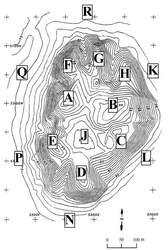
In my terminology, «a zone is a topographical portion of the site, without precise boundaries, and loosely identifiable for some recognizable traits, such as the nature of the contours or the presence of some distinctive surface feature. It is indexed numerically for units, and alphabetically for areas” (Grammar S2.6.1).
«The letters between A and S are reserved for topographic zones, and are the only ones that are used to define constituents proper. In our system, the letter I is omitted because it is graphically confusing, and M is omitted because it is used for “Mozan.” The letter O refers to the Outer City at Mozan/ Urkesh; so that every topographic zone in the Outer City includes always an initial O (this is the only instance where the code for zone contains two letters); zones in the Outer City approximately mirror the arrangement of zones on the High Mound. The letters S and OS are reserved for Special operations at any place on the High Mound or Outer City respectively.
It is a general practice to label operations either sequentially in the chronological order in which they are begun, or according to the grid. The sequence by topographical features as we have done in Mozan seems preferable, because it provides for every single item or feature an immediate sense of orientation within the site as a whole, while avoiding the complexities of labels based on the geometrical grid.» (Grammar, S3.4.1)
Back to top: Zones
The High Mound
There are eight hilltops and spurs within the High Mound.
The higher ones are the five hilltops in the central and southern portion of the High Mound: they are labeled A through E. The hilltop to the extreme south (D) and the one to the northeast (B) have extensive modern cemeteries on them, which are no longer in use.
To the north, there are three spurs, which are lower in elevation. they are labeled F, G and H.
The five southern hilltops encircle a large, depressed flat area at the center, which is labeled J. This area was used regularly as a soccer field by the local youth until our excavations began to encroach on it.
The Expedition House is located on the northern slopes of zone B.
Three roads used to cross the High Mound, one between E and A, one between D and C, and one between G and H. The latter is the one that is still in use to reach the Expedition House.
The foothills of the High Mound are divided into six zones (K through R), divided according to what appear roughly as sides of a polygon. They cover generally the area of the early city wall and of the escarpment/moat in front of it. They also reach to the area of the Outer City that is most immediately connected with the High Mound.
Back to top: Zones
The Outer City
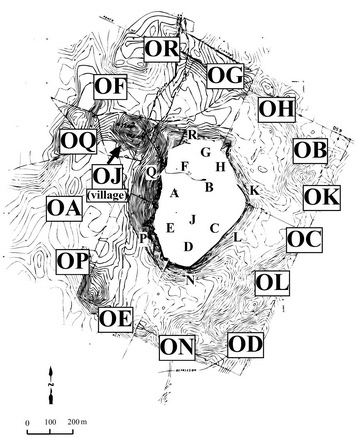
Since the Outer City has no salient features in the relief, the zones are assigned as sections which match the High Mound zones, but with the prefix beginning with O (for Outer City).
Each zone may roughly be perceived as a truncated cone, with the wider part overlapping the outer city wall. The narrower part of the cone adjoins the foothill zones of the High Mound (K through R).
The two most salient features in the Outer City are the modern village of Mozan (OJ), and the ring markes by slghtly higher elevations that correspond to the ancient outer city wall.
A road encircles the entire High Mound, and five roads exit radially to the northwest, the west, the southwest, the southeast, and the north. All roads are unpaved (at our request, except for a small portion of the northern road (from the outer city wall to the village of Mozan), which links the site with the Amuda-Qamishly road to the north.
A modern cemetery was established at the beginning of our excavations in the northern portion of the outer city wall. It serves the town of Umm er-rabiya, and set in place before we realized that the Outer City extended that far.
Back to top: Zones

