2. IDENTIFICATION
Designation
| Roster | Date | Author | Record |
|---|---|---|---|
| Description (summary) | 2003-08-15 | ms | pre-excavation opening shots of k1, facing east. [Input: N815MS.j] |
3. STRATIGRAPHY
Recovery/Assignment
| Roster | Date | Author | Record |
|---|---|---|---|
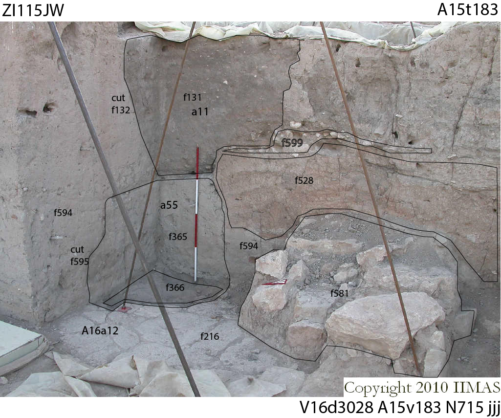
| Harmonization | 2024-01-11 | jw | This view confirms that pit a11 was filled with ashy soil, f131. However, it stops at the top of the collapsed section of wall f528. Below this point, the cut in courtyard floor, f216, is filled by a completely different soil, f365. One must conclude that the phase 5 pit a11, near Khabor kilns, did not reach the courtyard and that an earlier pit, here designated a55 (with cut f595 and fill f365), was cut to rob courtyard stones in phase 4. [Input: ZI111jW.j] |
| Notes on recovery | 2024-01-11 | jw | This view was taken at the onset of excavations in season 2003-N. Unit A15 had lain dormant for two years and had been covered for preservation. This particular spot was the northeast corner at the junction of units A16 and A15, and encompassed the formal palace courtyard, A16a12. After going out of use, it was gradually covered with accumulations. In successive occupation periods, pits were dug down to the level of the courtyard and stones were robbed. This corner was an example, and it was exposed by two teams, one working from the top and another from the side. Neither documented the complete situation and it could not be fully understood. [Input: ZI111jW.j] |
6. REFERENCE
Analogical Record
| Roster | Date | Author | Record |
|---|---|---|---|
| Template | |||
| Photo of context (v view) | |||
| View/drawing of aggregate | 2003-07-14 | jw | a11 (pit) a55 (pit aggregate) [Input: ZH330jW.j] |
| View/drawing of features | 2003-07-14 | jw | f131 (fill) f132 (pit) f216 (pavement, type b) f228 (lens type c) f365 (fill) f366 (packing) f528 (wall) f581 (wall) f594 (accumulation A) f595 (pit cut) f599 (pavement, type c) [Input: ZH330jW.j] |
| View/drawing of locus | 2003-07-14 | jw | k1 [Input: ZH330jW.j] |
| View/drawing orientation | 2003-07-14 | jw | looking east [Input: ZH330jW.j] |
| Text description of view | 2003-07-14 | jw | Shows the relationship between pits a11 (phase 5) and a55 (phase 4). Also shows the part of wall, f528 that collapsed to the north and overlay wall foundation, f581. Notable from the photo is a sherd and stone path, f599, directly atop the wall collapse. [Input: ZH330jW.j] |
| Web view | |||


