Back to top: Overview
Location
Unit J4 is located east of the monumental access to the Temple, represented by the Primary Apron and the Stone Staircase
(respectively features J2f130 and J2f129), which were exposed during the 2002-4 excavation seasons.
This unit incorporates early exploratory trench excavated as part of B6.
|
|
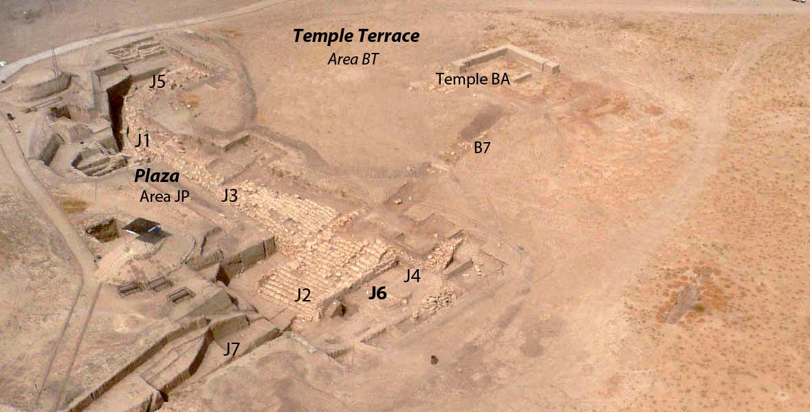 |
J6 began as a unit south of J4, when it became clear that the architectural layout we anticipated when J4 was started did not materialize, and that the southern extension would best be seen together with the area to the north, where J4 was located.
Back to top: Overview
Pertinent area
JP is the main area to which unit J4 belongs: it includes the Temple Plaza and Terrace Edge.
J4 is located to the east of the monumental temple access, and can be identified as an area for service activities.
Back to top: Overview
Background
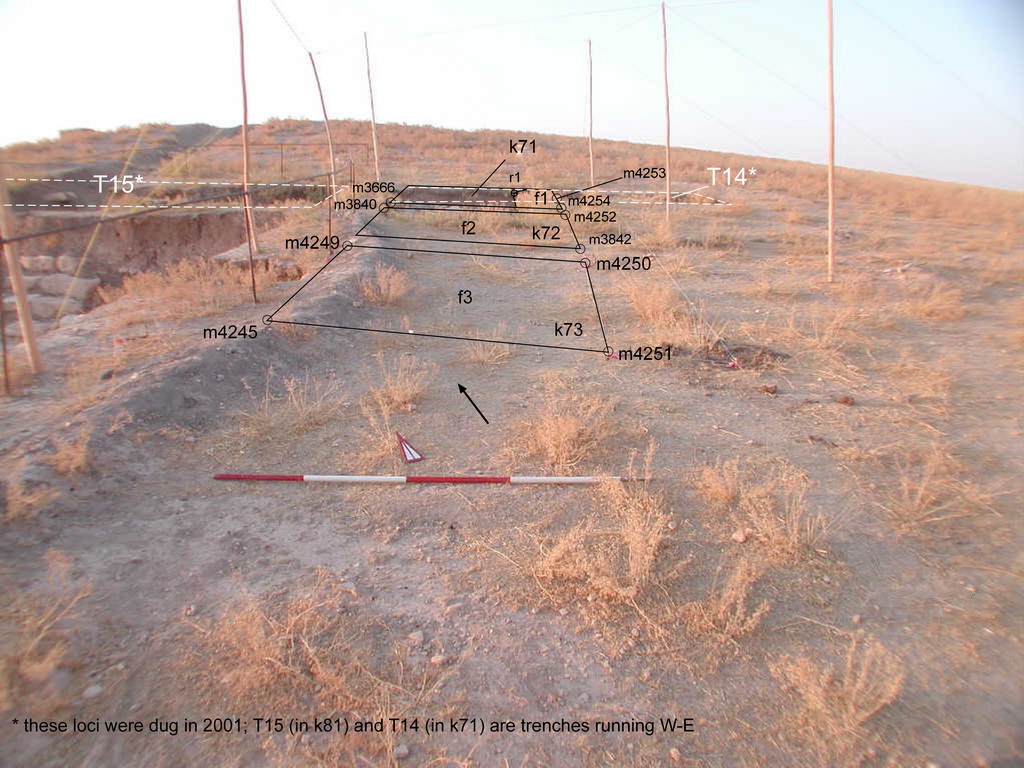
The stone staircase was partially exposed during the investigations carried out in 2001 in this portion of the terrace mound by a team of the university of Tübingen (directed by Peter Pfälzner). Their operation in this sector was labeled B6. In light of this recovery, in the 2002 excavation season, unit J2 was set west and around the portion of the stone staircase, which lead to the exposure of an extended stone structure. The staircase proper was labeled J2f130, while the stepped structure to the west, defined as the main Apron, was labeled J2f131 and J2f132. The excavations in J2 also exposed a portion of a wall (J2f129) flanking the staircase to the east.
One of the ‘German’ trenches, T14 (a 10m trench with a W-E alignment) exposed portions of a stone structure located approximately 9 meters east of wall J2f129, which, in light of the excavations carried out in J2 during the 2004-5 season, was thought to be part of a (possible) western Apron, assuming a specular arrangement of the monumental staircase complex. It was to test the possibility of such a specular arrangement that it was decided to open Unit J4.
Back to top: Overview
Goals
In the 2006 excavation season, J4 has been set immediately east to J2 Unit with the following aims:
1- understand whether the secondary Apron as exposed in J2 area continued on the east, and, in this case, determine its extension), thus determining if f10 was part of it.
2- Determine whether the area east to the monumental staircase could have been the eastern limit of the ‘monumental access’ to the temple terrace, If the excavations reveal that f10 is not the extension of the apron.
3- A more general aim was to understand the activities that were carried out in the area east to the ‘monumental staircase’.
In the 2006 excavation season, J4 has been set immediately east to unit J2 with the following aims:
- to understand whether the secondary Apron as exposed in J2 area continued on the east, and, in this case, determine its extension), thus determining if f10 was part of it;
- to determine whether the area east of the monumental staircase could have been the eastern limit of the ‘monumental access’ to the temple terrace, if the excavations reveal that f10 is not the extension of the apron;
- a more general aim was to understand the activities that were carried out in the area east to the ‘monumental staircase’.
For this reason, J4 Unit was initially set around f10, the stone structure exposed by the ‘German’ trench T14.
Back to top: Overview
Physiognomy
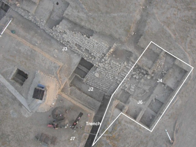
J4 was started as a test excavation aimed at clarifying what we expected to be a specular situation of the Temple Terrace monumental staircase. As it turned out, this was to be a seminal excavation that instead highlighted, for the first time, a great propensity for asymmetry in Urkesh architecture.
This led the way for the subsequent excavations in J6, which expanded considerably the scope in a lateral direction, both to the south and to the north.
|
|
 |
Excavations in J4 also confirmed the same direct superposition of strata separated by a gap of more than one thousand years that we had already seen in J1 and J2. The excavation carried out in J4 started from the topsoil (Phase h8-JPA) and exposed Late and Middle Mittani layers. In a deep sounding within locus k100, a 3rd millennium BC layer was unearthed right below Mittani layers.
Below is a brief presentation of the main features and constructs that gave J4 its identity and defined its function:
Back to top: Overview
The eastern boundary of the revetment wall
What is most indicative of the propensity for asymmetry is wall f10. This stone structure appears to form the eastern boundaries of the revetment wall, but higher to the north. In addition to the difference in elevation and position, there is also a morphological architectural difference, where this boundary closes with an angle as opposed to the circular shape of the revetment wall.
Back to top: Overview
The 3rd millennium directly above Mittani deposits
The deep sounding in k100 yielded late Calcolithic sherds right below layers that yielded Mittani sherds. This puzzling situation was cleared during the excavations of J6, where it became clear that 3rd millennium material are deposited right above Early Mittani.
Back to top: Overview
The Mittani use phase
The Middle Mittani is the phase where activities started taking place in this area, evidenced by the rebuilding phase to which many structures in J4 pertain. This includes the bin installation f93, walls (f170, f159) and tannurs (f112, f152).
Back to top: Overview
Phases
The stratigraphy of J4 is similar to J2 and J6 with 3rd millennium B.C. levels directly below Mittani layers.
The excavation carried out in Unit J4 allow to define the following Phases:
h8-JPA modern: is related with the activities that took place in modern times. This Phase is represented by the trenches dug in 2001 during an investigation of this portion of the Tell.
h85-MZA modern: this Phase is related with the upper layers, such as the topsoil and the accumulations below the topsoil which are washed or eroded layers and natural accumulations that build-up the tell surface for approximately 1 meter.
h67-MZA Late Mittani: similar to Phase 85-MZA, since Phase 67-MZA is as well related to the build-up of the tell surface due to natural accumulations; it is represented by thick layers of natural accumulations that build up the area for approximately another meter.
h65-MZA Late-Middle Mittani: the excavations carried out in J4 area indicate that some activities started to take place in Phase 65-MZA, a period in which major rebuilding took place in different areas of the temple mound (as we know from J2J2 and J4 areas). It is dated to the Late-Middle Mittani Period. In the J4 area, this ‘rebuilding phase’ is represented by different mud-brick and stone structures, concentrated mainly in few loci (k71- k73, k62). Within this Phase a dump took place in the whole J6 area (cfr. J6 ^dump1 ), which interested the southern portion of J4 area as well.
h63-MZA Early Mittani: this phase has been attributed, on the basis of the excavation carried out in the tell terrace, to the Early Mittani period. This period concerns a re-organization of the area around the so called ‘monumental staircase’. As part of this re-organization of the space East of wall J2f129, a series of glacis layers were placed on top of the tell mound and large stones were placed on top of the glacis layers. Concerning J4, there are no structures in use in this Phase; the only activities that tool place within this Phase are related to a glacis floor surface in two loci.
h32-MZA Imperial Akkadian: represented by two features dug in k100. In this locus we did a deep sounding at the end of the excavation season where we exposed a 3rd millennium B. C. layer right below Mittani accumulations. The stratigraphy here found is similar to J6 Unit: also in this area a similar stratigrapical situation was found, and 3rd millennium B. C. levels were exposed directly below the Mittani layers (cfr J6 phase 4m-JPD ) in the last two excavation seasons.
Back to top: Overview
Beginning of excavations
J4 was initially set in the north portion of the Tell mound, around the stone structure, f10, and it expanded later toward south.
The area was subdivided in 15 loci.
In 2001 excavation season, some trenches with W-E alignment (respectively T15, T14 and T10), were dug by a team of the university of Tübingen directed by Prof. P. Pfälzner during a sounding in this portion of the Tell mound. The loci of J4 were placed in a way that covers these trenches incorporating them into stratigraphy of J4.
|
|
 |
Back to top: Overview
End of excavations
The excavations in J4 area ended on September 18, 2006. The photo to the right demonstrates the final stage of J4 excavations. The most notable features are:
- The glacis layer f127 exposed in the north portion of the J4 Unit, in loci k82 and k72, dating to the Early Mittani period (see 74).
- The Middle Mittani structures concentrated in the central portion of the area (a2 and related features) (see v73c).
- k100, the deep sounding which revealed a 3rd millennium B. C. layer right below Middle Mittani accumulations (see v84).
|
|
 |
Back to top: Overview
Main results
The main results of the 2006 season may be summarized as follows.
- f10 does not belong to a a possible secondary Apron, as thought before the beginning of the excavations, and the question about the nature of this stone structure is open to further investigation.
- Below the topsoil and related layers (tell surface and erosion), there is a sequence of Mittani accumulation layers, which indicate that this portion of the mound was not used until the Late-Middle Mittani period.
- Early Mittani levels (Phase h63-MZA) were reached in a deep sounding in k100, located directly on top of a third millennium BC layer (cfr. h32-MZA). The same depositional situation can be found in the J6 and J2 units.
- A glacis layer covers the area East of wall f129, which could be seen as the eastern boundary of the 'monumental staircase'(f130) and of the monumental complex as exposed in J2
- The nature and function of two stone walls (f84 and f157), located at a higher elevation in respect to other structures, remains unclear.
- The only well defined structure is the bin f93. (fig.1).
- Among the most notable objects found in J4 is plaque depicting a soldier and a prisoner q16.1 (fig.2)
- An interesting find comes from pit f85, a complete skeleton of a Saluki dog i5 (fig.3) and frog bones i6. no other material were found in association with these 2 items.
|
|
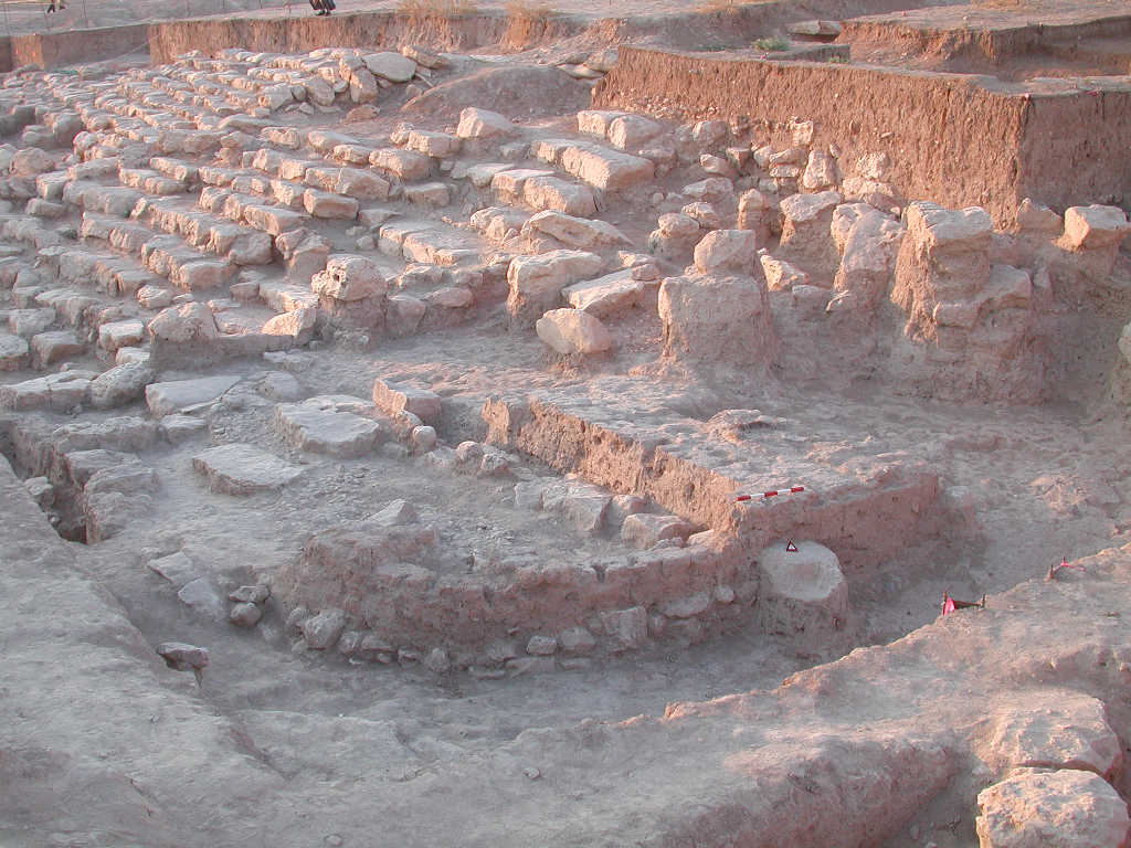 Fig.1: bin f93 Fig.1: bin f93
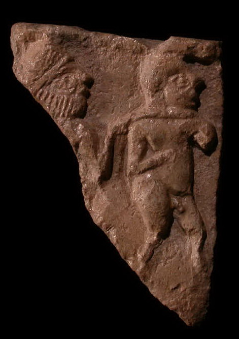 Fig.2: plaque q16.1 depicting a soldier and a prisoner scene Fig.2: plaque q16.1 depicting a soldier and a prisoner scene
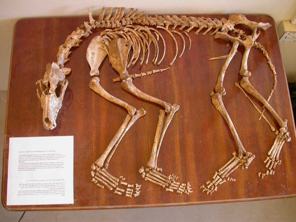 Fig.3: the complete skeleton of Salouki dog i5 Fig.3: the complete skeleton of Salouki dog i5 |
Back to top: Overview
General statistics
For more details refer to the data set section.
| approximate cubic meters
|
658
|
| total number of features
|
171
|
| total number of items
|
6
|
| total number of q-lots
|
302
|
| total number of sherds
|
Not fully processed yet
|
| total number of output files
|
1,632
|
| total number of records
|
21,196
|
| total number of hyperlinks
|
27,363
|
| total number of photographs
|
267
|
| total number of drawings
|
49
|
| total file size (with low resolution graphic files)
|
Not fully processed yet
|
Back to top: Overview