2. IDENTIFICATION
Designation
| Roster | Date | Author | Record |
|---|---|---|---|
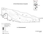
| Description (summary) | 2001-08-21 | lR | Entire East section of k4 and k8 compiled into one drawing. The drawing has been traced with freehand and shows the extent of excavations in that area. The top shows the natural slope of the area with top soil layers and brickmelt layers below. Two walls of a10 are visible on the left hand side, and f93 at the bottom. This section is a composite which includes w12, w60, and w61. [Input: W314LC.j] |
6. REFERENCE
Analogical Record
| Roster | Date | Author | Record |
|---|---|---|---|
| Drawing of context (w 2-D) | |||
| View/drawing of aggregate | 2001-08-21 | lR | a4 (brickfall) a8 (open area?) a10 (structure) [Input: W314LC.j] |
| View/drawing of features | 2001-08-21 | lR | f16 (topsoil) f17 (topsoil) f49 (layer) f52 (wall) f54 (brickfall) f56 (layer) f58 (accumulation B) f93 (wall) f113 (wall) [Input: W314LC.j] |
| View/drawing of locus | 2001-08-21 | lR | k4 k8 [Input: W314LC.j] |
| View/drawing orientation | 2001-08-21 | lR | e [Input: W314LC.j] |
