2. IDENTIFICATION
Designation
| Roster | Date | Author | Record |
|---|---|---|---|
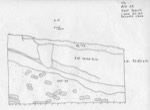
| Description (summary) | 2001-06-26 | sV | Section drawn by sV and dC with section string at 9240 elevation. The north section of k3 shows the topsoil level, melted brick layers below with a small animal hole cutting through these layers,and the brickfall below sloping north to south. The section was removed on L626. This section is part of a composite drawing. [Input: W314LC.j] |
6. REFERENCE
Analogical Record
| Roster | Date | Author | Record |
|---|---|---|---|
| Drawing of context (w 2-D) | |||
| View/drawing of aggregate | 2001-06-26 | sV | a4 (brickfall) [Input: W314LC.j] |
| View/drawing of features | 2001-06-26 | sV | f2 (topsoil) f47 (brickfall) f55 (layer) [Input: W314LC.j] |
| View/drawing of locus | 2001-06-26 | sV | k3 [Input: W314LC.j] |
| View/drawing orientation | 2001-06-26 | sV | e [Input: W314LC.j] |
| Notes on analogical record | 2001-06-26 | sV | Refer to composite w40 [Input: W314LC.j] |
