6. REFERENCE
Analogical Record
| Roster | Date | Author | Record |
|---|---|---|---|
| Photo of context (v view) | |||
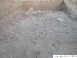
| View/drawing of features | 2004-07-05 | jw | f228 (pavement, type b) f233 (pavement, type c) f270 (pavement, type c) f301 (stone installation) f331 (stone installation) [Input: O911JW2.j] |
| View/drawing of locus | 2004-07-05 | jw | k25 [Input: O911JW2.j] |
| View/drawing orientation | 2004-07-05 | jw | looking west [Input: O911JW2.j] |
| Text description of view | 2004-07-05 | jw | Final photograph of k25, the westernmost locus along a line extending west from the SW corner of the abi. After removing modern accumulations filled with gully wash that contain material from Phase 3 to Phase 6, the horizontal layers in the baulks and the relative lack of water-transported cut stones reveal that this may have marked the western extent of the ancient gully. Excavation was suspended when we reached a pebble and sherd pavement, f233 and f270, dated to Phase 3 by pottery analysis, along the eastern edge of the locus. A few large tumbled stones, f301, a pile of smaller stones, f331, and a line of large, cut stones, f228, were at the bottom of this year's excavation here. [Input: O911JW2.j] |
| Web view | |||
