2. IDENTIFICATION
Designation
| Roster | Date | Author | Record |
|---|---|---|---|
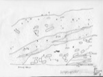
| Description (summary) | 2001-07-01 | lR | This section was originally drawn in MZ12 A13 by cI but has been retouched and inked by lR. The inked section is slightly off scale since the scanned image was elongated without the proper scaling tool and thus this section should only be used as a reference to features. One may refer to the original scanned image by A13 W12f107 A13k1n drawn in J807 which retains the actual scale or refer to the large north section w41 which has been properly adjusted. The section shows the layers above the brickfall,the brickfall,and the erosion of the layers under the brickfall. It also shows the slope of the area. This section is part of a composite drawing. [Input: W314LC.j] |
6. REFERENCE
Analogical Record
| Roster | Date | Author | Record |
|---|---|---|---|
| Drawing of context (w 2-D) | |||
| View/drawing of aggregate | 2001-07-01 | lR | a4 (brickfall) [Input: W314LC.j] |
| View/drawing of features | 2001-07-01 | lR | f27 (brickfall) f28 (accumulation a) f36 (floor, type a) f37 (band) f38 (layer) f39 (layer) f40 (layer) f41 (layer) f43 (layer) f57 (topsoil) [Input: W314LC.j] |
| View/drawing of locus | 2001-07-01 | lR | k1 [Input: W314LC.j] |
| View/drawing orientation | 2001-07-01 | lR | n [Input: W314LC.j] |
| Notes on analogical record | 2001-07-01 | lR | Refer to composite w41 [Input: W314LC.j] |
