6. REFERENCE
Analogical Record
| Roster | Date | Author | Record |
|---|---|---|---|
| Photo of context (v view) | |||
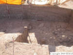
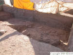
| View/drawing of features | 2004-07-05 | jw | f230 (floor, type b) f233 (pavement, type c) [Input: O911JW2.j] |
| View/drawing of locus | 2004-07-05 | jw | k15 k25 [Input: O911JW2.j] |
| View/drawing range | 2004-07-05 | jw | tight shot [Input: O911JW2.j] |
| View/drawing orientation | 2004-07-05 | jw | looking east [Input: O911JW2.j] |
| Text description of view | 2004-07-05 | jw | View of the southern part of the long section showing that the action of the ancient and modern gullies was more severe to the south. One can see the continuity between the pebble and sherd pavements in k15, f230, and in k25, f233. Shown also is the ramp cut from the E baulk of k25 to facilitate dirt removal as the excavation proceeds to the east. [Input: O911JW2.j] |
| Web view | |||

