[TOC] TEXT TO BE WRITTEN”
Back to top: Volumetric data ("topography")
Introduction
For our approach to volumetry see the relevant section in the Grammar.
Back to top: Volumetric data ("topography")
Loci and squares
The site of Tell Mozan is arranged in an excavation grid. Regular loci follow the grid defined by points. Depending on the special conditions of the terrain and of the excavation strategy, this grid can change in orientation.
| Unit | Regular loci | Special Loci | Total number | Image |
| J1 | J1 is constituted of a very extended area, counting about 19 regular (5x5 m) squares (loci). 4 loci belong to the first season and have been inglobed in the new oriented grid (Chronicle). 5 loci have been included in J5 since 2008. 4 loci (k7, k9, k10, k11) were used during the first excavation season (2003)and oriented following the North, and all the other loci following the orientation of the Temple Terrace. The regular loci have been used only during 2003-2006 excavation, then the deepness of the excavation required to re-modell the J1 area for safety reasons, in a theatre shape, where only new special loci were used. The regular loci (k7, k9, k10, k11) have been used in 2003, while loci k2-k41 between 2005 and 2006. | 2005 season the theatre shape of the excavation unit started to be set up. At the beginning the squares were located next to the revetment wall because the goal was to reach the level of the Plaza close to it (k107-k111). From 2006 it was started to enlarge the area because we tried to give the ancient perception of the wall and the terrace from a slightly bigger distance (k112-k118). In 2008 the excavation was concentrated at the bottom of the wall to look for the construction of the escarpments and to check eventual earlier levels (k119-k128). After the recovery of the stucture in k128, the 2009 season looked for the earlier structure and the possible LC mound(k127-k132). | 46 loci?? |   |
| J2 | There were 20 main squares in J2 when it was begun in 2004. In subsequent years some loci were reassigned to other excavation units. The main excavation loci of J2 then remained k2, k3, k4, k5, k12, k13, k14, k15. The loci were distributed to achieve a maximum exposure of the staircase, apron and revetment wall. Some were eventually subsumed under other units (k33, k43, k53 and k54 in Unit J3; k92, k82, k83, k84, k85 in unit J4 and J6) or were only shallow excavations. | 7 irregular special loci, k100 correspond to the position of the preexisting trench and k105 is a small sounding. K101 and k103 were created to have a stratigraphic control. K106 was created to built a cement staircase to acces J2 and k111 to include part of J7 into J2. | 32 loci over the course of 3 years of excavation |  |
| J3 | Eleven were regular 5m x 5m squares (k1, k2, k11, k12, k13, k21, k22, k23, k31, k32, and k103. Of the regular squares, three were first excavated in a previous season by unit J2 (k11, k21, and k31). Four were partial squares excavated to clear sightlines to the revetment wall and aprons (k90, k91, k92, k93, and k94). | 6 irregular loci. Loci k90, k91, k92, k93, and k94 are of irregular shape and were excavated to improve sightlines from a new viewing platform to the south. Special locus k110 was opened in the latter part of a study season M23(2010-U) to identify the source of a large quantity of Late Chalcolithic sherds found in the vicinity of the Early Dynastic glacis (f50 and f109). | 21 or 23 loci | 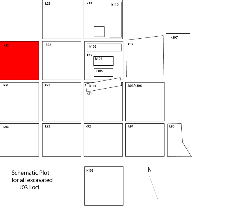 |
| J4 | Out of the 18 loci that constitute unit J4, 13 loci were excavated during the season of 2006, k61, k62, k63, k64, k70, k71, k72, k73, k74, k80, k81, k82, k83, k84, k100. | Only one irregular locus was introduced in order to investigate the continuation of the J2 apron in J4. To achieve that, the southern part of k83 and the northern part of k84, were excavated as k100. | 18 loci |  |
| J5 | 21 square loci (...) | 9 irregular loci | 30 loci |  |
| J6 | Nine regular 5x5m squares (k82, k83, k84, k70, k71, k72, k73, k74, k75, k64, k65) | 4 are irregular shaped and smaller in size loci (k85, k86, k87). A special locus is k200, which corresponds to the trench excavated by the German team in jears 1998-2002. Five smaller loci (k101, k102, k104, k105, k106) were opened within the regular loci to allow for smaller o deeper soundings. | 22 loci | |
| J7 | None of the J7 loci adhere to the 5x5 meter excavation squares that are usually used in the excavation, because the loci were arranged according to preexisting conditions. | The loci were laid out according to the site grid using corner markers to delineate the western edge of the squares and using the trench, k200, as the eastern edge. This line formed the western edge of k4, however, in k1, k2, and k3 the western edge was cut on an oblique line to reduce the size of J7 and create an increasingly wide viewing area of the J2 staircase as one approaches from the south. | 8 loci | < > > |
|
To the right are the regular squares. |

|
|
To the right are the irregular squares. They follow the excavation grid, but are smaller because of the trench to the west. |

|
|
To the right are the loci. They do not follow the excavation grid, are smaller and made for test soudings. |

|
Back to top: Volumetric data ("topography")
Size and volume of excavations
Not all of loci and squares were excavated from the topsoil. Not all of them reached the same bottom elevation, depending fron the stratigraphy and the excavation goals. Sometimes some squares were first excavated in one Unit and then incorporated in anotherone (for example In J6 or J1). Often the archaeological context does not allow to excavate all the squares at the same depth and special loci with irregular shapes were created. Rather generic calculations of the areas and volumes excavated within each unit are included in the following table.
| Unit | J1 | J2 | J3 | J4 | J5 | J6 | J7 | TOTAL |
|---|---|---|---|---|---|---|---|---|
| Area | 400 m2 | 500 m2 | 400 m2 | 300 m2 | 550 m2 | 350 m2 | 100 m2 | 2600 m2 |
| Volume | 1100 m3 | 750 m3 | 700 m3 | 658 m3 | 900 m3 | 400 m3 | - | 4508 m3 |
The total area consists of approximately 2600 m2, although not all excavated to the same depth, while the cubic meters amount to little more than 4500 m3, which turns out to be a notable quantity and it is also due to the presence of areas where large quantities of material dating back to to the Mitannian period inside the plaza have been removed (for example J1, J2 and J5).
Back to top: Volumetric data ("topography")
Sections
All drawings are numbered sequentially (“w” indicates drawings). For each locus we draw the northern and eastern sections. These sections are numbered from w1 to w51. If we have a number of pieces of sections we combine them. These sections are numbered sequentially from w100 to w112. The combination of several sections within many loci are w200, w201, w206, w300.
|
There are several composite sections that span across two or more loci, and the map to the right indicates the appropriate location. in view drawings are the individual sections. |

|
Back to top: Volumetric data ("topography")
Plots and floor plans
Floor plans are generated from plots that reproduce the schematic outline of elements found in the ground. If there are complex structures, these are drawn in situ and get a sequential drawing number. A special project was represented by the complete documentation of the structure of the Temple Terrace. All the exposed structures were drawn stone by stone at a scale 1:50 for its ground plan. The measurements for the drawing were taken with the total station from the survey monuments. All the drawings were then digitalized in AutoCAD in order to place the structures on the topographic plan of Tell Mozan. This floor plan has a drawing sequential number.
We draw also special sections of the structures, showing the profile of walls and staircases. In J6 are following sections:
1. Section C-C’ showing the steps of the staircase and the western face of the staircase flank wall: w600
2. Section H-H’ showing walls 218 and 227: w602
3. Section D-D’ showing the width of the staircase flank wall: w603
Back to top: Volumetric data ("topography")
Control points
The markers used in J6 are:
| 2930 3810 3813 3816 3817 3820 | 3821 3828 3829 3830 3833 3834 3835 3836 3838 3930 4171 4245 4295 4301 | 4717 4718 4719 4720 4722 4724 4732 4763 4808 4809 | 4817 4866 4867 4869 4907 6196 6197 6198 6199 6201 6202 |
Back to top: Volumetric data ("topography")