Back to top: Plaza
Introduction
Most of the structures of the Temple Terrace excavated to date are located on the boundary between the mound (Area BT) and the Plaza (Area JP). This is due to an excavation strategy aimed at uncovering the monumental southern part of the Temple Terrace facing the Plaza.
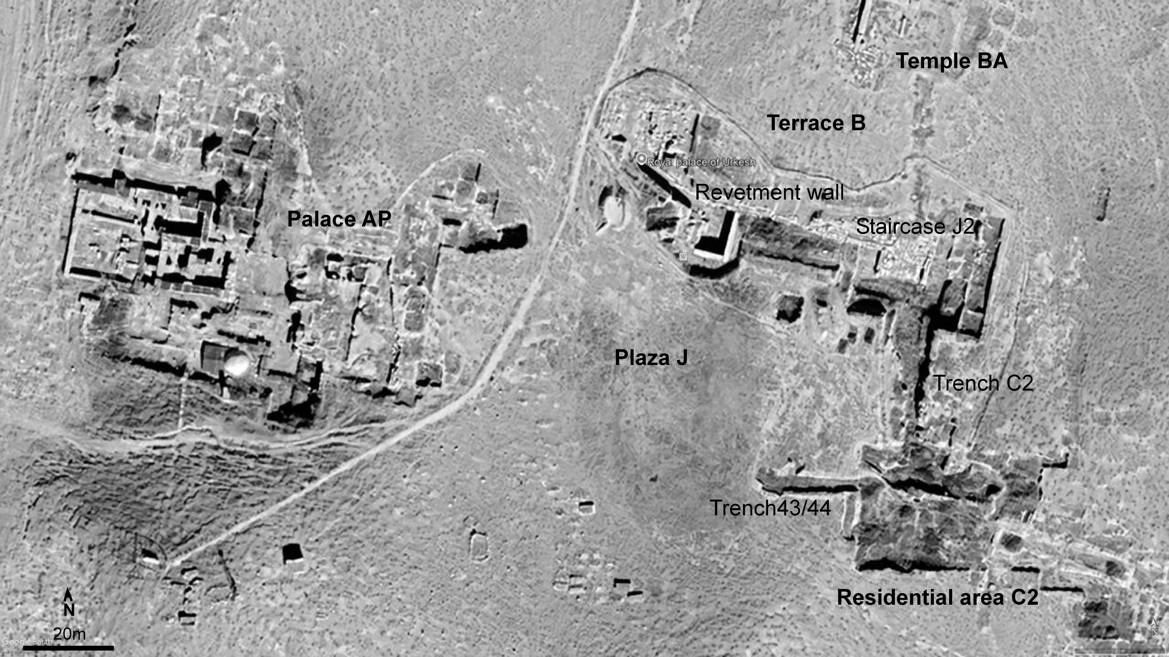
The Plaza is a large open space located in the center of the settlement, facing the Temple Terrace. Its purpose is to provide a view of the monumental sacred complex with its walls, stairs and temple. Surely the open space was used for other purposes in the city and in function of the temple and palace. About this topic see function of the plaza
The plaza is bounded to the north by the revetment wall and the monumental staircase, to the south by the residential area in C2, and to the west by the royal palace of Tupkish. In the east we have also structures, which were coming to light in J6.
Back to top: Plaza
Topography
Zone J occupies a central depression within the tell. The accumulation of deposits in this area was slower than elsewhere on the mound, due to the limited presence of architectural remains.
During the spring rainy season, this area is the first part of the site to develop vegetation, as the deeper, less disturbed soils retain more moisture. In summer, Zone J appears darker than the surrounding areas because the absence of architectural structures allows soil moisture to persist for a longer period. By contrast, areas containing buried structures generally have shallower soils and reduced water retention, causing them to dry out more rapidly.
The depression visible today was also in the Third Millennium BC (see L. Crescioli 2012 the plaza mistery. what evidence do we have for this depression in the EDIII?
|
Google Earth aerial photo October 2025
|
Back to top: Plaza
Geomagnetic prospections
The magnetometry carried out in 2006 show the structures of the Temple Terrace clearly. The revetment wall and staircase appear as a white linear anomaly accompanied by a darker anomaly. At the western curve of the revetment wall, a linear dark anomaly can be observed and is interpreted as a street approximately 10 m wide.
The western edge of the plaza is clearly defined by a straight anomaly, which likely corresponds to the eastern wall of Palace AP.
In contrast, the southern boundary of the plaza is less clearly defined and remains the most uncertain of its limits owing to the lack of excavation data from this area. The situation is clearer in the southeast, where the residential quarter excavated in Area C2 is located. Here houses are located fronting the plaza. A white “L” shaped anomaly is visible, which is building XV in C2. To the east, additional anomalies are present, marking the end of the lighter, apparently undisturbed area.
At the center of the surveyed area, in Zone J, a homogeneous zone characterized by lighter magnetic values and an absence of significant anomalies can be observed. This pattern in this sector suggests the absence of substantial buried architectural remains and the presence of the plaza.
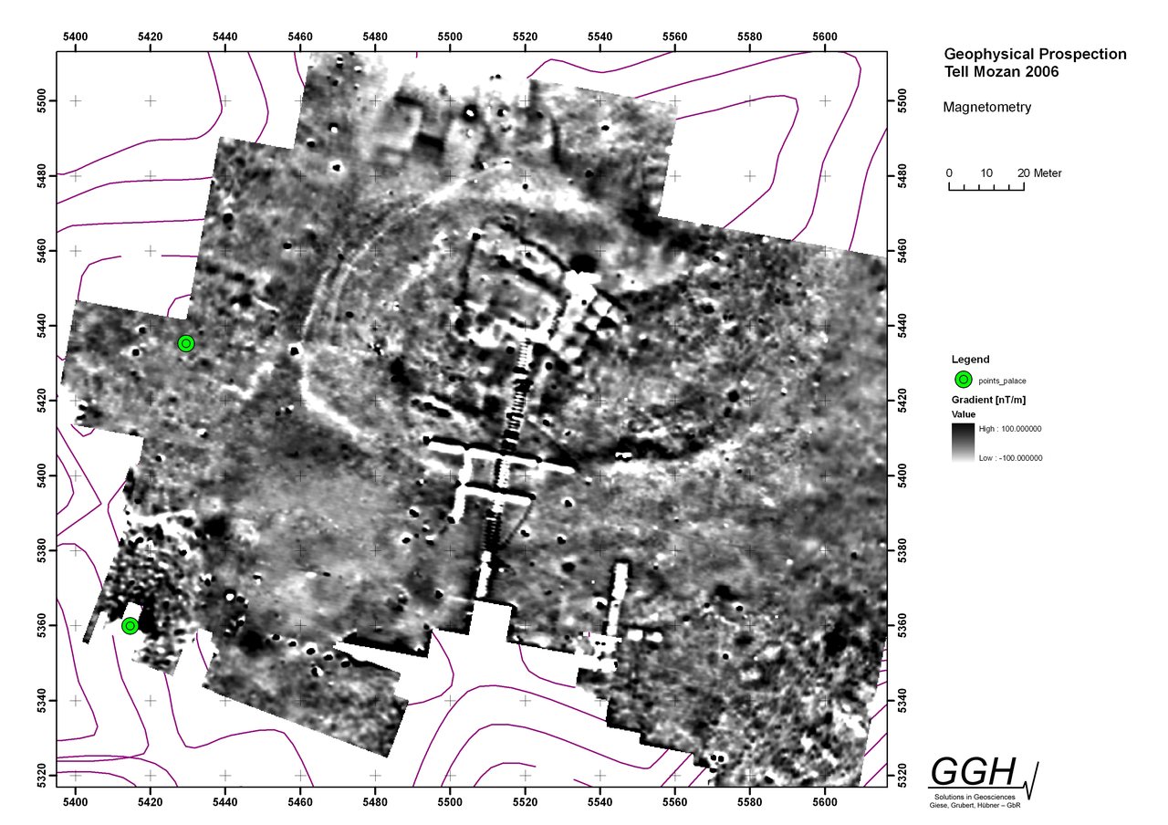
Magnetometry 2006
|
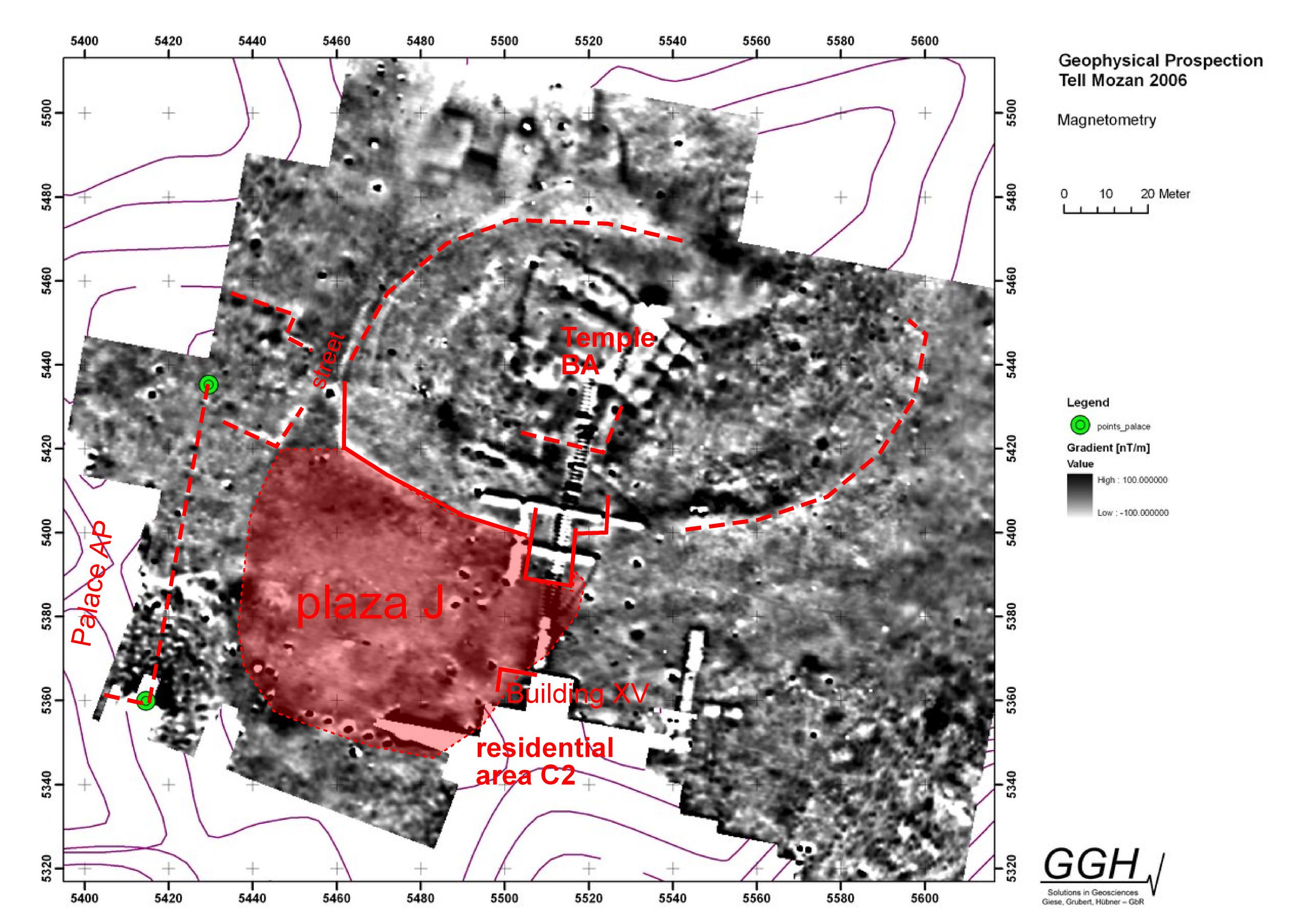
Interpretation of Magnetometry 2006
|
Back to top: Plaza
Excavations
|
Eight excavation units (A19, J5, J1, J3, J2, J6, J7, C2) help us to define the extension and estabilish the chronology of the plaza. A more detailed description of the results of excavations is in chronology.
|
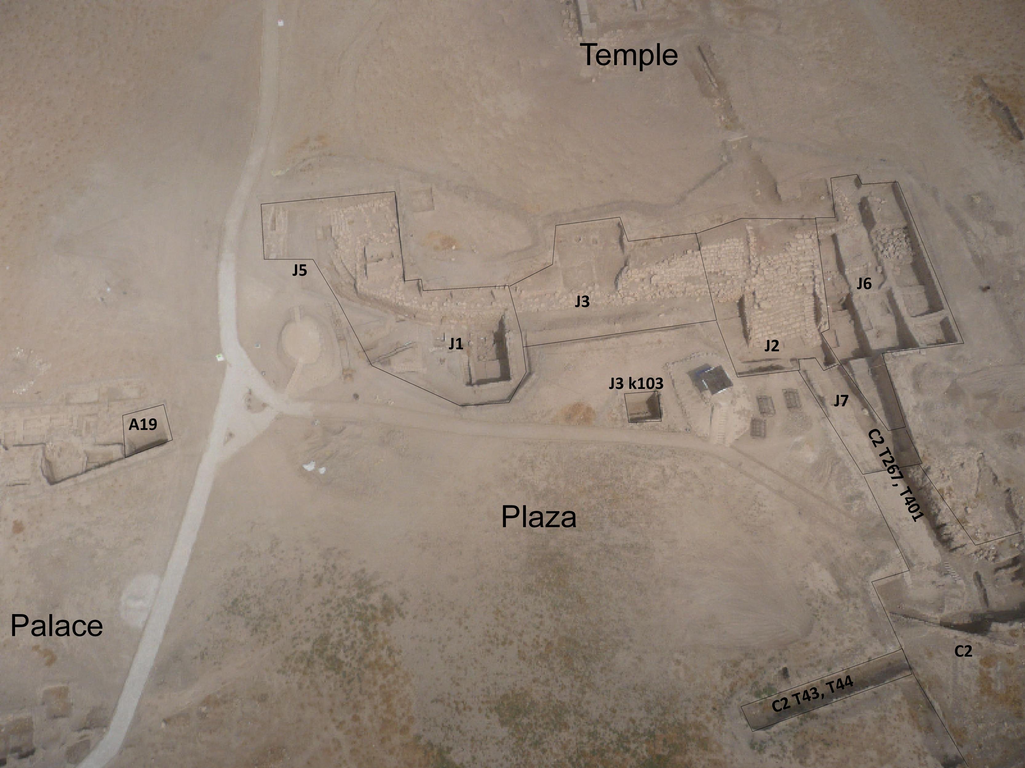
Overhead of area JP in year 2009 with excaavtion units
|
In Units J2 and J6, in front of the staircase, the plaza was extensively exposed for 15 m east-west and 12 m north-south to a depth of 6 m. A regular sequence of floor levels dating from 2800 to 2000 BC was recorded. However in J2, floor levels dationg to 1500 BC were found directly overlying third millennium BC floors. This stratigraphic discontinuity resulted from an imposing erosion coming from the east caused by water, that removed the intermediate sequence of deposits.
The missing sequence of floors dating between 2000 to 1500 BC is documented in trench C2, where the erosion did not removed them (about this topic see chronology erosion and chronology Middle Bronze Age here is a problem whith chronology. Pfälzner has our Phase 4 and 5 (2000-1800) where we have surely mittanni, for example the brickfall. How can I explain it? we have a mass pottery in J2+J6+J7. In C2 was excavated in trench).
To the southeast in Unit C2 is a residential area. Between C2 and the staicase in J2, the plaza was exposed in a 2 m wide trench for 35 m north-south to a depth of 5 meters with a deposition from 2200 to 1700 BC. A trench starting from Area C2 (T43, T44) explored the plaza for 20 m to the west. (A floor (Inst.524, 525, 105) is found from the staircase in J2 until here in Phase C5 (2000-1800 BC) insert in ^JP.
To the west in A19 we have evidence that the Palace bounded directly onto the plaza itself. The elevations of the floor level of the plaza and the elevation of the stone courtyard in the palace match, whicvh is about 485 m above sea level (our elevations in the Urkesh Global record is 8500 m).
At the western curve of the revetment wall, an additional portion of the plaza was exposed in Units J5 and J1. Here, plaza floor surfaces were documented over a distance of approximately 35 m southeast–northwest and to a depth of 6 m. The stratigraphic sequence spans the period from ca. 2800 to 2400 BC.
The subsequent sequence dating between 2400 and 1400 BC (mKB 2016 from 2600 to 1400 B.C.) is absent in this area. As a result, floors of the ED III period are found directly beneath Mittani-period floors, indicating that the intervening deposits are absent, not in consequence of abandonment ( the plaza mistery). There are no floors or deposits, no evidence of dumping activities, and no pits or structures of the kind that would normally be expected in an open area located at the center of a city. Throughout this period of approximately 900 years, the area appears to have been deliberately kept clean and maintained as an open plaza. The situation directly to the west is compleatly different, where a contiuous deposition and construction has been documented from the Akkadian to the Mittani period (Kelly-Buccellati 2016, 104-105).
This situation changed during the Mittani period, when the area was gradually infilled, eventually resulting in the accumulation of deposits up to 3 m thick. This process may be explained by several factors. First, it may be related to the construction of structures or walls along the southern edge of the plaza Wall Inst 702 in Trench C2 at the southeastern end of the plaza, dated to Phase C6 (ca. 1900 BC). Second, the collapse of buildings located east of the plaza, the debris from which partially covered the lower portion of the staircase in Unit J2, reduced the dimensions of the plaza and allowed a faster deposition.
Continuing eastward from J1, we encounter unit J3, where the central section of the revetment wall was excavated. Aproximately 30 m south of the revetment wall, in k103, a sounding was done to a depth of 3.50 m. The excavations recorded a regular depositon of natural accumulations, extending to a Mittani floor level at a depth of 3.50 m (elevation of 8826@bottom J3f76). The deposits were extremely hard and difficult to excavate, being described in the field records as “cement like” accumulations. The exceptional hardness of these deposits may be explained by local hydrological conditions. This area likely retained water for longer periods, leading to the formation of temporary puddles. Repeated wetting, settling, and drying of fine sediments would have resulted in highly compacted accumulations, giving the deposits their characteristic cement-like consistency.
Back to top: Plaza
Literature
Bianchi et al 2014, 28-33.
Buccellati 2012
Kelly-Buccellati 2016, 105.
Buccellati F. 2017, 38.
Back to top: Plaza