Analogical record
|
f1 k1 |
| Template | 1998-7-24 | jLW.jpg | OH02t1 [Input file: I714JL.J / I714JL.-J V614CJC.J / V614CJC.-J |
|
|
f1 k1 |
| Template | 1998-7-24 | jLW.jpg | OH02t1 [Input file: I714JL.J / I714JL.-J V614CJC.J / V614CJC.-J |
| Orientation | 1998-7-5 | jL | looking south [Input file: I714JL.J / I714JL.-J] |
| Description of view | 1998-7-5 | jL | general-see Sketch 1 [Input file: I714JL.J / I714JL.-J] |

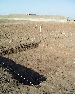
| B1.Photo | 1998-7-5 | jW | L_V11d6012 |
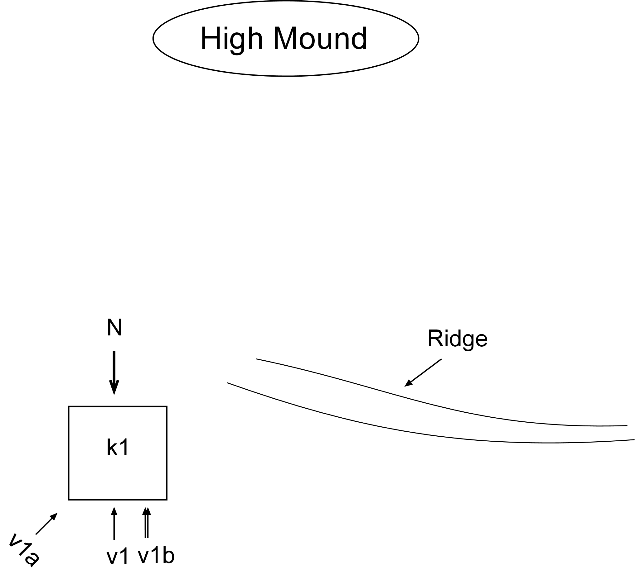
| Notes on analogical record | 1998-7-13 | jW | informational view taken on the first of excavation to show the general orientation of the square within its present environment. v1 looks south to show k1 set on a small rise of the outer rim of a depression between k1 and the main tell. v1a, to the SW shows k1 against the most prominent and nearest part of the elevated outer perimeter, sometimes speculated to be the outer wall of the city. v1b is a thght view of the square and f1 looking west. [Input file: I714JLW.J / I714JLW.-J] |
| 1998-7-24 | jW | Informational photos taken on the first day of excavation to show the general orientation of the square and its environment. v1a shows the ridge near k1 while v1b shows workmen excavating topsoil, f1. [Input file: V614CJC.J / V614CJC.-J] |
| Feature(s)within view | 1998-7-5 | jL | f1 [Input file: I714JL.J / I714JL.-J] |
| Locus/i within view | 1998-7-5 | jL | k1 [Input file: I714JL.J / I714JL.-J] |
| Range | 1998-7-5 | jL | medium shot [Input file: I714JL.J / I714JL.-J] |
| Orientation | 1998-7-5 | jL | looking southwest [Input file: I714JL.J / I714JL.-J] |
| Description of view | 1998-7-5 | jL | k1 abd city wall-see Sketch 1 [Input file: I714JL.J / I714JL.-J] |

| B1.Photo | 1998-7-5 | jW | L_V11d6014 |
| Feature(s)within view | 1998-7-5 | jL | f1 [Input file: I714JL.J / I714JL.-J] |
| Locus/i within view | 1998-7-5 | jL | k1 [Input file: I714JL.J / I714JL.-J] |
| Range | 1998-7-5 | jL | medium shot [Input file: I714JL.J / I714JL.-J] |
| Orientation | 1998-7-5 | jL | looking south [Input file: I714JL.J / I714JL.-J] |
| Description of view | 1998-7-5 | jL | k1 focus-see Sketch 1 [Input file: I714JL.J / I714JL.-J] |

| B1.Photo | 1998-7-5 | jW | L_V11d6013 |

|
f1 f2 f3 k1 |
| Template | 1998-7-8 | gB.JPG | Oh02t2 [Input file: I714JL.J / I714JL.-J |
| Orientation | 1998-7-7 | jL | looking west [Input file: I714JL.J / I714JL.-J] |
| Description of view | 1998-7-7 | jL | W baulk-see Sketch 2 [Input file: I714JL.J / I714JL.-J] |
| B2.View Web | 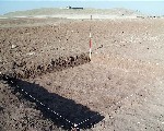 11d6010 |
 11d6011 |

| B1.Photo | 1998-7-8 | gB | L_V11d6010 |
| Notes on analogical record | 1998-7-8 | gB | Informational views looking to the southwest, taken on the third day of excavation showing the general orientation of the square with respect to its setting, which includes the main tell, a small adjacent ridge and the tens of a family of nomadic herders. [Input file: V614CJC.J / V614CJC.-J] |
| 1998-7-13 | jW | informational views, taken on the third day of excavation to show general orientation and record the characteristics of the landscape. The digital camera and Freehnd, a computer drawing program, will be used to prepare a template in lieu of marking up Polaroid photos with a pen. [Input file: I714JLW.J / I714JLW.-J] |
| Feature(s)within view | 1998-7-7 | jL | f1, f2, f3 [Input file: I714JL.J / I714JL.-J] |
| Locus/i within view | 1998-7-7 | jL | k1 [Input file: I714JL.J / I714JL.-J] |
| Range | 1998-7-7 | jL | wide shot [Input file: I714JL.J / I714JL.-J] |
| Orientation | 1998-7-7 | jL | looking southwest [Input file: I714JL.J / I714JL.-J] |
| Description of view | 1998-7-7 | jL | see Sketch 2 [Input file: I714JL.J / I714JL.-J] |
| B2.View Web | 11d6010 |
11d6011 |

| B1.Photo | 1998-7-8 | gB | L_V11d6011 |
| General Notes | 1998-7-8 | gB | This view aims at showing rise from the north. The blue pickup on the right, Jim and John on the left, serve as a point of reference at the summit of the ridge. The shots were taken as I walked further to the north: the widest view was taken at some 350 paces from the excavations, and it takes in the high tension pole and behind it left edge of the High Mound all the way to the cemetery on the right. The shots closer to the ridge show two tents which are pitched in the depression between the ridge and the tell: these tents are not visible from a distance, and this gives a good perceptual gauge of the height of the ridge. [Input file: I707GB.J / I707GB.-J] |
|
f1 f2 f3 f4 k1 |
| Template | 1998-7-23 | jLW.jpg | OH02t3 [Input file: I714JL.J / I714JL.-J |
| Range | 1998-7-7 | jL | medium shot [Input file: I714JL.J / I714JL.-J] |
| Orientation | 1998-7-7 | jL | looking north [Input file: I714JL.J / I714JL.-J] |
| Description of view | 1998-7-7 | jL | c5116-20 [Input file: I714JL.J / I714JL.-J] |
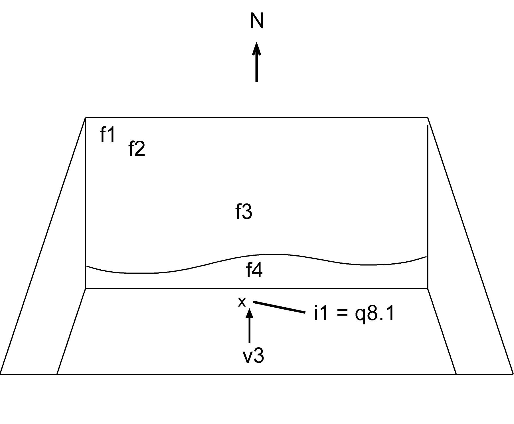
| Notes on analogical record | 1998-7-20 | jW | illustrates the position where the first seal ( i1) was found. It was within an accumulation layer ( f4), and the photo, looking north, shows f1- f4 in the background. [Input file: I721JLW.J / I721JLW.-J] |
| 1998-7-23 | jW | Shows where the first sealing was found, within the accumulation layer f4. [Input file: V614CJC.J / V614CJC.-J] |

|
f1 f2 f3 f4 f5 k1 |
| Template | 1998-7-11 | jLW.jpg | OH02t4 [Input file: I714JL.J / I714JL.-J |
| Range | 1998-7-7 | jW | medium shot [Input file: I714JL.J / I714JL.-J] |
| Orientation | 1998-7-7 | jW | looking north [Input file: I714JL.J / I714JL.-J] |
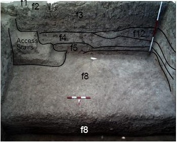
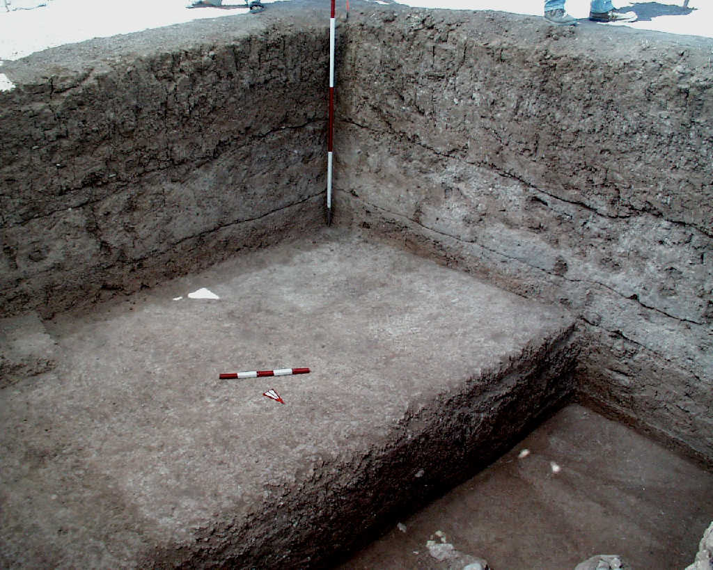
| Description of view | 1998-7-11 | jW | illustrates all the features excavated to date, with particular focus on the soil ( f1, f2, f3) and accucumulation ( f4, f5) features. It illustrates how they were more or less uniformly layered. The view also shows the absence of containment for the accumulation and the top of a possible pit feature just discovered. [Input file: I711JLW.J / I711JLW.-J] |
| B2.View Web | 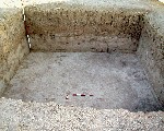 11d6001 |

| B1.Photo | 1998-7-11 | fAB | L_V11d6001 |
| Notes on analogical record | 1998-7-11 | jW | View looking north showing all the features excavated as of I711, with particular emphasis on the soil ( f1, f2, f3) and the accumulation ( f4, f5) features. It illustrates that they were uniformly layered and that there is no obvious containment. [Input file: V614CJC.J / V614CJC.-J] |
|
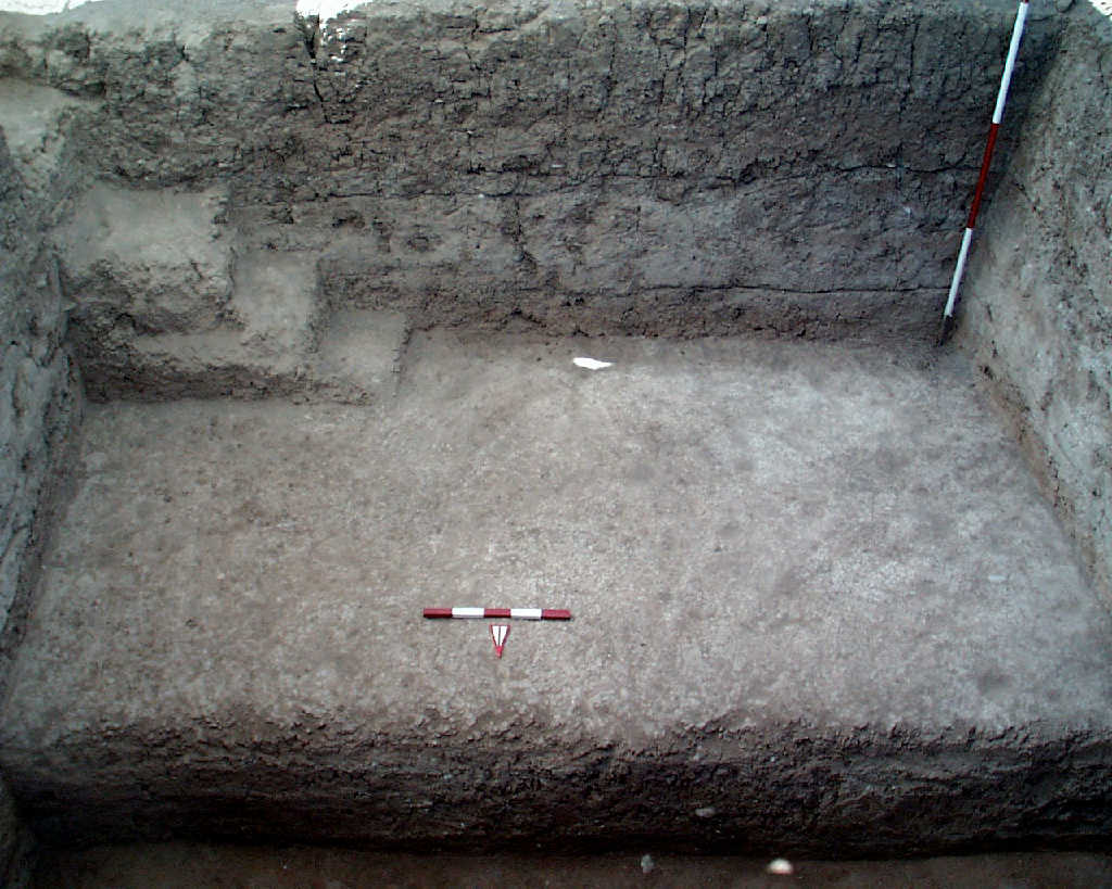
f1 f2 f3 f4 f5 f8 k1 |
| Template | 1998-7-24 | jLW.jpg | OH02t5 [Input file: I714JL.J / I714JL.-J |
| Range | 1998-7-13 | jW | medium shot [Input file: I714JL.J / I714JL.-J] |
| Orientation | 1998-7-13 | jW | looking north [Input file: I714JL.J / I714JL.-J] |
| Description of view | 1998-7-13 | jW | c5318-23 [Input file: I714JL.J / I714JL.-J] |
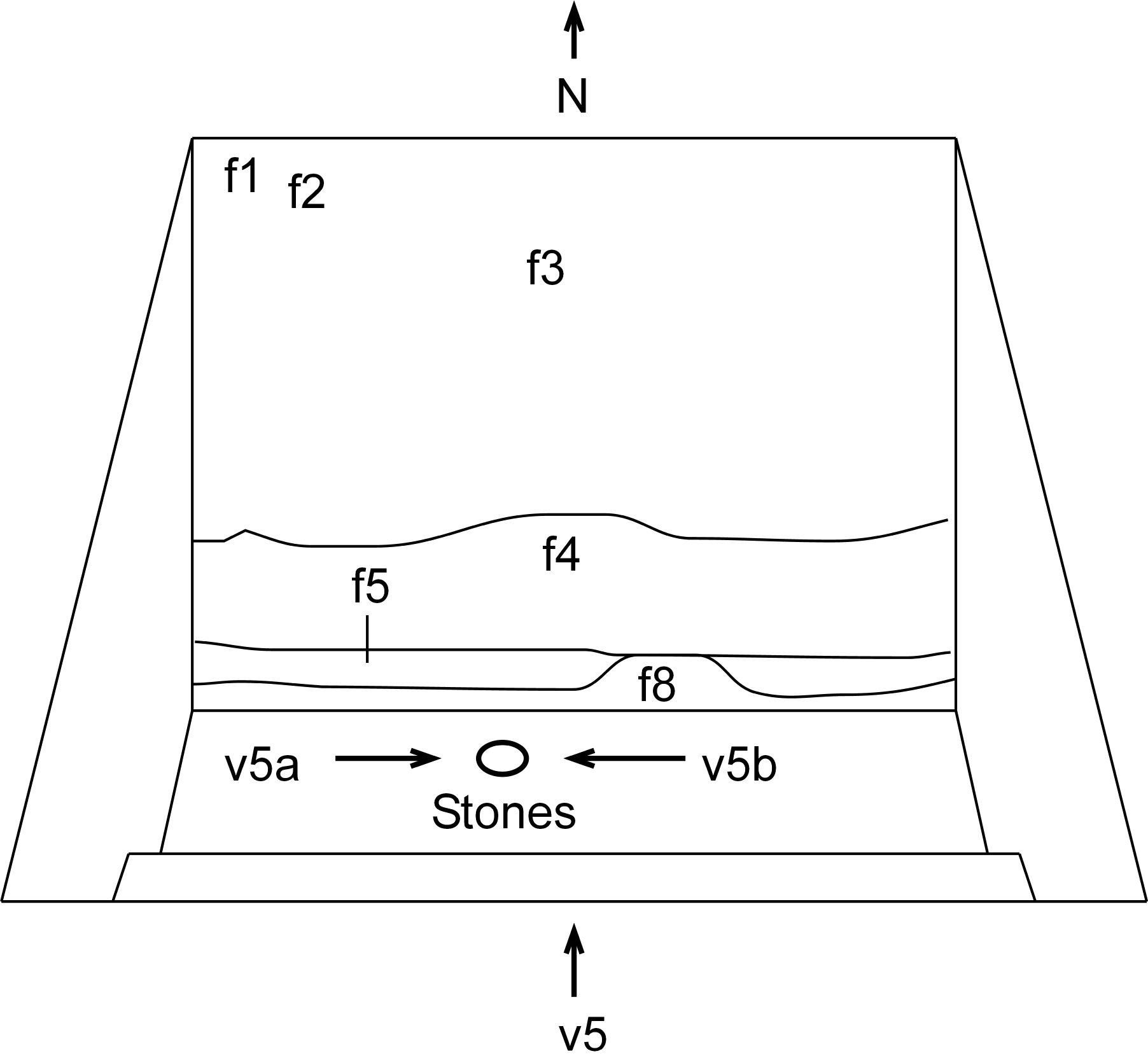
| Notes on analogical record | 1998-7-13 | jW | illustrates the complete stratification of k1 as of this date. Most prominent is f5, a fill and f8 a thick layer of laminations below, which is still being excavated. It is taken to the north and includes f1-5 and f8. It also highlights an organized pile of stones in the NW quadrant that was discovered in the last pick run. Not clear in the picture is the location of a small patch of charcoal in the NW quadrant along the west baulk. v5a is a tight view looking east showing the pile of stones, while v5b is a similar tight view looking west. This view represents an interim stage, for the record, hence we did not call the photographer. [Input file: I714JLW.J / I714JLW.-J] |
| 1998-7-24 | jW | Shows the complete stratification excavated as of I713. It also highlights a pile of stones in the NW quadrant. [Input file: V614CJC.J / V614CJC.-J] |
| Feature(s)within view | 1998-7-13 | jW | f8 [Input file: I714JL.J / I714JL.-J] |
| Locus/i within view | 1998-7-13 | jW | k1 [Input file: I714JL.J / I714JL.-J] |
| Range | 1998-7-13 | jW | medium shot [Input file: I714JL.J / I714JL.-J] |
| Orientation | 1998-7-13 | jW | looking east [Input file: I714JL.J / I714JL.-J] |
| Feature(s)within view | 1998-7-13 | jW | f8 [Input file: I714JL.J / I714JL.-J] |
| Locus/i within view | 1998-7-13 | jW | k1 [Input file: I714JL.J / I714JL.-J] |
| Range | 1998-7-13 | jW | medium shot [Input file: I714JL.J / I714JL.-J] |
| Orientation | 1998-7-13 | jW | looking west [Input file: I714JL.J / I714JL.-J] |
| Description of view | 1998-7-13 | jW | c5324-25 [Input file: I714JL.J / I714JL.-J] |
|
k1 |
| Template | 1998-7-24 | jLW.jpg | OH02t6 [Input file: I714JL.J / I714JL.-J |
| Range | 1998-7-13 | jW | wide shot [Input file: I714JL.J / I714JL.-J] |
| Orientation | 1998-7-13 | jW | looking west [Input file: I714JL.J / I714JL.-J] |
| Description of view | 1998-7-13 | jW | no template [Input file: I714JL.J / I714JL.-J] |
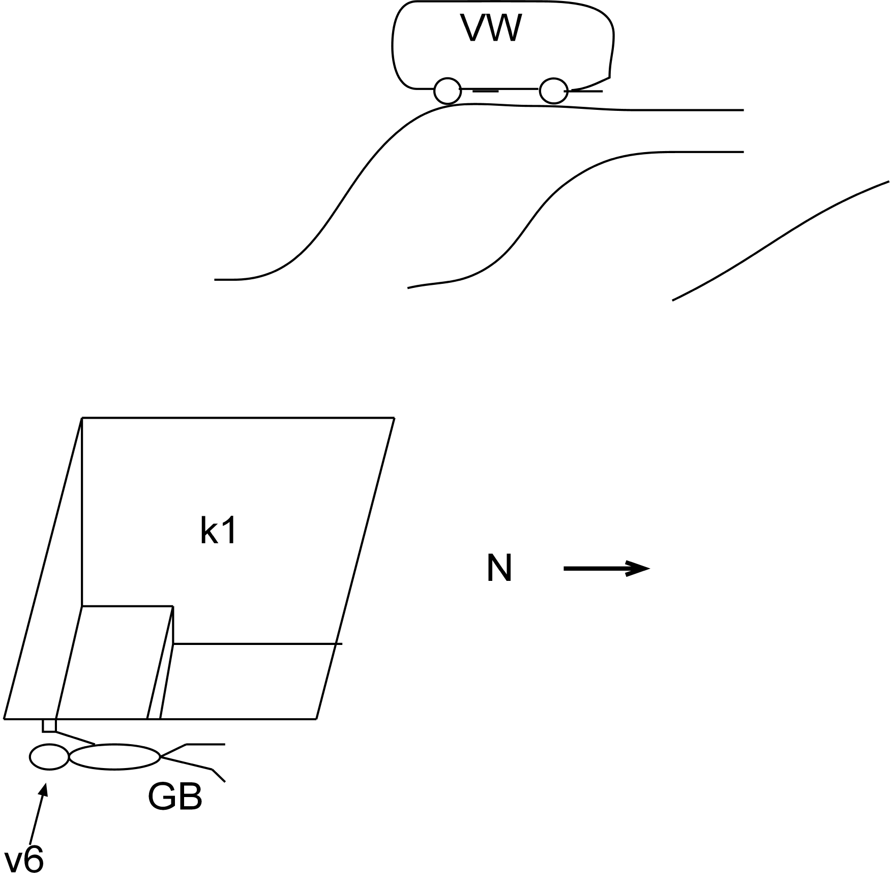
| 1998-7-13 | gB | I took the picture (C5327) laying low, near surface of tell just outside k1, looking W. Adel Kareem's face is visible from within locus, Ahmad Omo is standing on W edge. In the background (and this is the point of the picture) a sharp rise is visible, with Volkswagen parked right on top. This rise is likely to cover a structure linked with our finds in k1. [Input file: I714JLW.J / I714JLW.-J] | |
| Notes on analogical record | 1998-7-24 | jW | I took the picture laying low, near surface of tell just outside k1, looking West. Abdel Kareem’s face is visible from within locus, Ahmed Omo is standing on W edge. In the background (and this is the point of the picture) a sharp rise is visible, with VW parked right on top. This rise is likely cover a structure linked with our finds in k1. [Input file: V614CJC.J / V614CJC.-J] |
|
f8 k1 |
| Template | 1998-7-25 | jLW.jpg | OH02t7 [Input file: I714JL.J / I714JL.-J |
| Orientation | 1998-7-13 | jW | looking east [Input file: I714JL.J / I714JL.-J] |
| Description of view | 1998-7-13 | jW | c5334-35 [Input file: I714JL.J / I714JL.-J] |
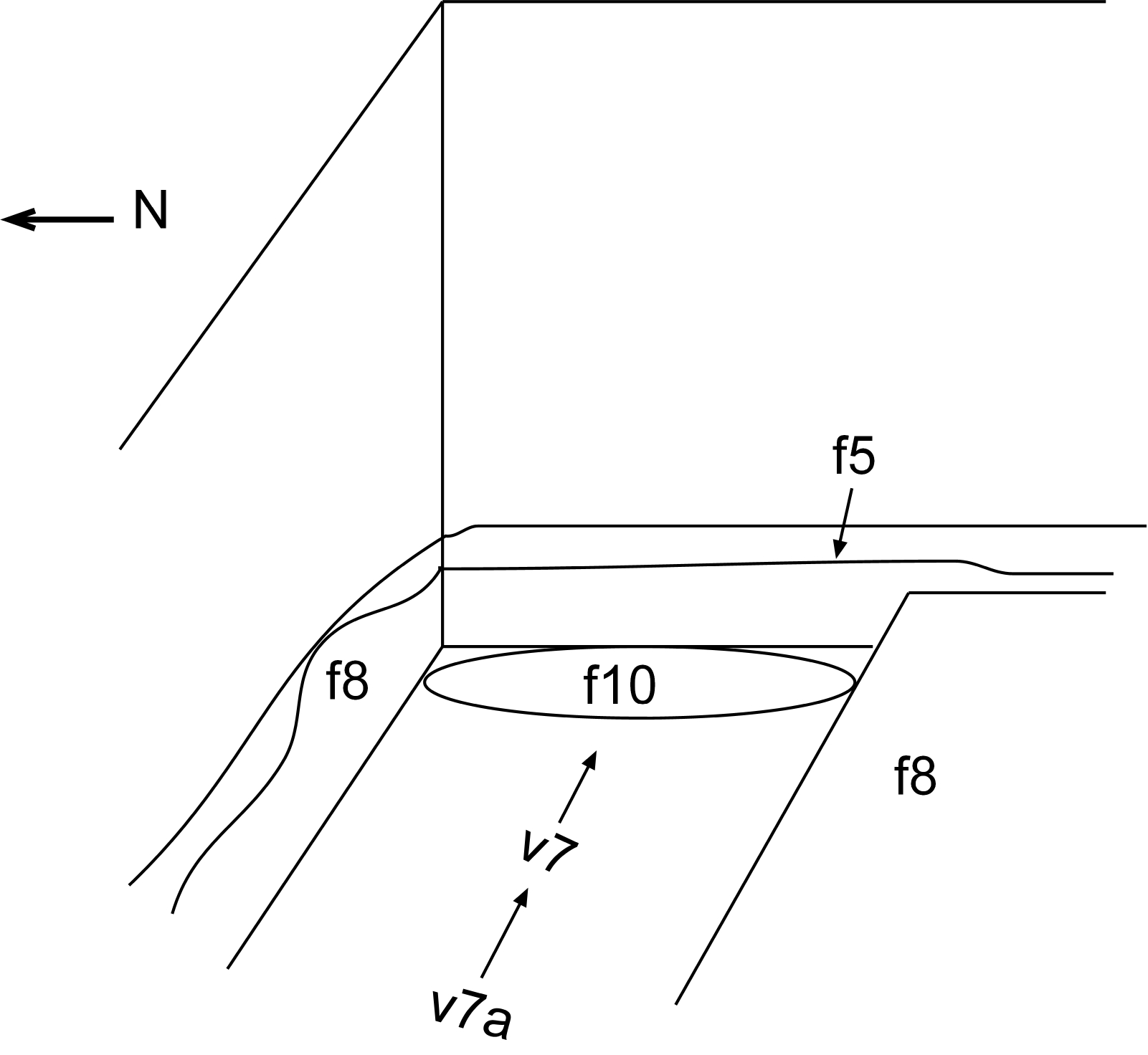
| Notes on analogical record | 1998-7-13 | jW | identifies the extent and orientation of a circular patch of brown soil within an area of soil that is more red. v7a shows its relationship to the east baulk and to f8 and f5. [Input file: I714JLW.J / I714JLW.-J] |
| 1998-7-25 | jW | Identifies the extent and orientation of a brown patch of soil ( f10), which intrudes into f8. v7a shows its relationship to the East baulk, f5 and f8. [Input file: V614CJC.J / V614CJC.-J] |

|
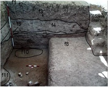
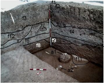
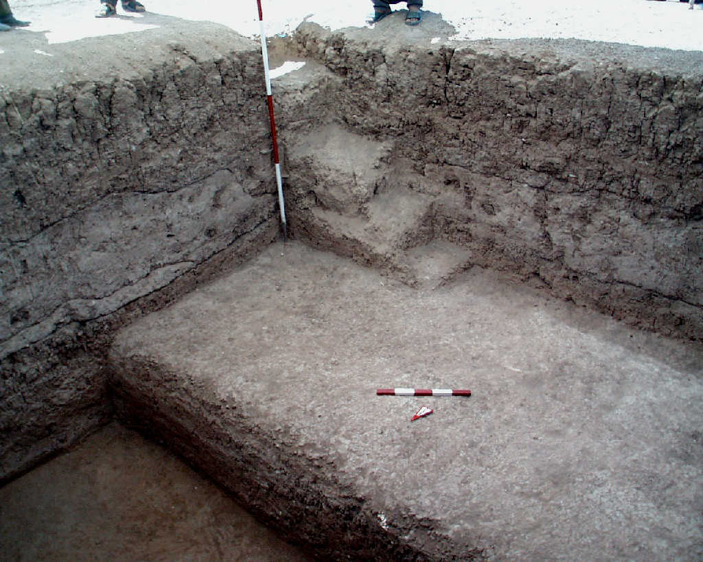
f1 f2 f3 f4 f5 f8 f9 f10 f11 k1 |
| Template | 1998-7-22 | jLW.jpg | OH02t8 [Input file: I714JL.J / I714JL.-J |
| Orientation | 1998-7-14 | jL | looking north [Input file: I714JL.J / I714JL.-J] |
| Description of view | 1998-7-14 | jL | N section [Input file: I714JL.J / I714JL.-J] |
| B2.View Web | 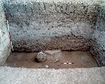 11d6002 |

| B1.Photo | 1998-7-14 | fAB | L_V11d6002 |
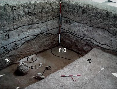
| Notes on analogical record | 1998-7-14 | gB | main view of Northern section at the end of excavation. f9 is scored but is not marked in the section nor was it while digging down. It represents the alternation within f8 of granular and flaky, which we have interpreted alternatively as subfloor and laminations. The patches of stones (some pedestalled within f8) are indicicative of the alignment. [Input file: I714JLW.J / I714JLW.-J] |
| 1998-7-15 | jW | v8a is a wide shot to show the north baulk's relationship to the rest of the square, including adjacent baulks and the less-excavated south half of the square. v8b is a tight shot to highlight the stones and their relationship to the newly emerging f11. v8c is a tight shot showing the relationship of f10 to f8. [Input file: I715JLW.J / I715JLW.-J] | |
| 1998-7-22 | jW | Final photo of the Northern section at the end of the excavation. [Input file: V614CJC.J / V614CJC.-J] |
| Feature(s)within view | 1998-7-14 | jL | f1, f2, f3, f4, f5, f8, f9, f10, f11 [Input file: I714JL.J / I714JL.-J] |
| Locus/i within view | 1998-7-14 | jL | k1 [Input file: I714JL.J / I714JL.-J] |
| Range | 1998-7-14 | jL | wide shot [Input file: I714JL.J / I714JL.-J] |
| Orientation | 1998-7-14 | jL | looking north [Input file: I714JL.J / I714JL.-J] |
| Feature(s)within view | 1998-7-14 | jL | f8, f11 [Input file: I714JL.J / I714JL.-J] |
| Range | 1998-7-14 | jL | tight shot [Input file: I714JL.J / I714JL.-J] |
| Orientation | 1998-7-14 | jL | looking north [Input file: I714JL.J / I714JL.-J] |
| Description of view | 1998-7-14 | jL | stones [Input file: I714JL.J / I714JL.-J] |
| Aggregate(s) within view | 1998-7-14 | jL | a1, a2 [Input file: I714JL.J / I714JL.-J] |
| Feature(s)within view | 1998-7-14 | jL | f3, f4, f5, f8, f12 [Input file: I714JL.J / I714JL.-J] |
| Locus/i within view | 1998-7-14 | jL | k1 [Input file: I714JL.J / I714JL.-J] |
| Range | 1998-7-14 | jL | tight shot [Input file: I714JL.J / I714JL.-J] |
| Orientation | 1998-7-14 | jL | looking north [Input file: I714JL.J / I714JL.-J] |
| Description of view | 1998-7-14 | jL | E side of N section [Input file: I714JL.J / I714JL.-J] |

|
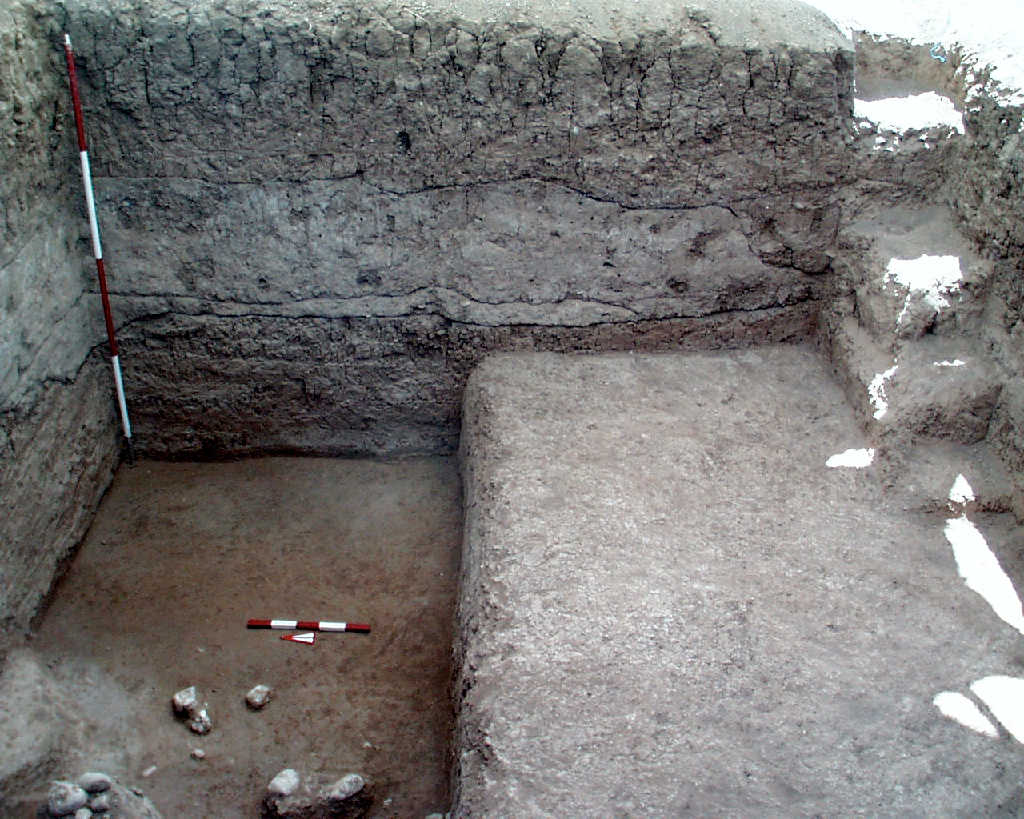
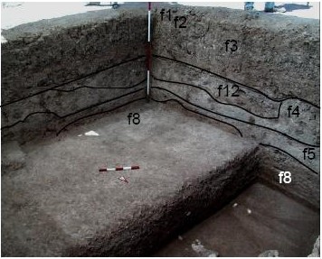
f1 f2 f3 f4 f5 f8 f9 k1 |
| Template | 1998-7-22 | jLW.JPG | OH02t9 [Input file: I714JL.J / I714JL.-J |
| Orientation | 1998-7-14 | jL | looking west [Input file: I714JL.J / I714JL.-J] |
| B2.View Web | 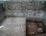 11d6004 |

| B1.Photo | 1998-7-15 | gB | L_V11d6004 |
| Notes on analogical record | 1998-7-15 | jW | main view of the Western section of the excavation. Visible are f1- f5 and f8. Also, as in v8, v9 is scored but not marked in the section. Also visible and not scored is a lens or pocket of soil/accumulation between f3 and f4. It has the consistency of f3, but more of the reddish coloration of f4. v9a is a wide shot that shows the relationship of the North, South and West baulks. [Input file: I715JLW.J / I715JLW.-J] |
| 1998-7-22 | jW | * is location of rodent hole [Input file: V614CJC.J / V614CJC.-J] | |
| 1998-7-22 | jW | Main view of Western section at the end of the excavation season. It shows f1, f2, f3, f4, f5, f8, f9, f12, a1 and a2, along with the unexcavated “platform” of f8 in the Southern half of the square. [Input file: V614CJC.J / V614CJC.-J] |
| Feature(s)within view | 1998-7-14 | jL | f1, f2, f3, f4, f5, f8 [Input file: I714JL.J / I714JL.-J] |
| Range | 1998-7-14 | jL | wide shot [Input file: I714JL.J / I714JL.-J] |
| Orientation | 1998-7-14 | jL | looking west [Input file: I714JL.J / I714JL.-J] |
|
f1 f2 f3 f4 f5 f8 f12 k1 |
| Template | 1998-7-22 | jLW.JPG | OH02t10 [Input file: I714JL.J / I714JL.-J |
| Orientation | 1998-7-14 | jL | looking south [Input file: I714JL.J / I714JL.-J] |
| Description of view | 1998-7-14 | jL | includes stairs [Input file: I714JL.J / I714JL.-J] |
| B2.View Web | 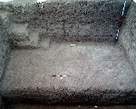 11d6005 |
| B1.Photo | 1998-7-15 | gB | L_V11d6005 |
| Notes on analogical record | 1998-7-15 | jW | main view of the Southern section of the excavation. Visible are f1- f5, f8, the access stairway to the east and a lens or pocket of soil in the western half between f3 and f4. Also appearing in section in the lower portion of the picture is the unexcavated southern half of f8, left when the focus shifted to the north part of the square. [Input file: I715JLW.J / I715JLW.-J] |
| 1998-7-22 | jW | Final photo of the Southern section at the end of the excavation. [Input file: V614CJC.J / V614CJC.-J] |
| Feature(s)within view | 1998-7-14 | jL | f8 [Input file: I714JL.J / I714JL.-J] |
| Locus/i within view | 1998-7-14 | jL | k1 [Input file: I714JL.J / I714JL.-J] |
| Range | 1998-7-14 | jL | tight shot [Input file: I714JL.J / I714JL.-J] |
| Orientation | 1998-7-14 | jL | looking south [Input file: I714JL.J / I714JL.-J] |
|
f1 f2 f3 f4 f5 f8 f10 f11 k1 |
| Template | 1998-7-22 | jLW.JPG | Oh02t11 [Input file: I714JL.J / I714JL.-J |
| Orientation | 1998-7-14 | jL | looking east [Input file: I714JL.J / I714JL.-J] |
| Description of view | 1998-7-14 | jL | E section [Input file: I714JL.J / I714JL.-J] |
| B2.View Web |  11d6003 |
| B1.Photo | 1998-7-22 | gB | L_V11d6003 |
| Notes on analogical record | 1998-7-15 | jW | main view of the Eastern section at the ind of the excavation. Visible are f1- f5 and f8. The access stairway is shown along the southern edge. [Input file: I715JLW.J / I715JLW.-J] |
| 1998-7-22 | jW | Final photo of the Eastern section at the end of the excavation. [Input file: V614CJC.J / V614CJC.-J] |
| Feature(s)within view | 1998-7-14 | jL | f8, f11 [Input file: I714JL.J / I714JL.-J] |
| Range | 1998-7-14 | jL | tight shot [Input file: I714JL.J / I714JL.-J] |
| Orientation | 1998-7-14 | jL | looking east [Input file: I714JL.J / I714JL.-J] |
| Description of view | 1998-7-14 | jL | stones [Input file: I714JL.J / I714JL.-J] |
|
f1 f2 f3 f4 f5 f8 f9 |
| Template | 1998-7-22 | jLW.JPG | OH02t12 [Input file: I714JL.J / I714JL.-J |
| Orientation | 1998-7-14 | jL | looking northwest [Input file: I714JL.J / I714JL.-J] |
| B2.View Web |  11d6006 |

| B1.Photo | 1998-7-15 | jW | L_V11d6006 |
| Notes on analogical record | 1998-7-15 | jW | view to the Northwest at the end of the excavation showing the perspective from the top of the baulk, looking down into the square. v12a is a tight shot to show the complex relationship between f5, f8 and f9. [Input file: I715JLW.J / I715JLW.-J] |
| 1998-7-22 | jW | * is location of rodent burrow [Input file: V614CJC.J / V614CJC.-J] | |
| 1998-7-22 | jW | Final photo of the Northwestern corner at the end of the excavation. [Input file: V614CJC.J / V614CJC.-J] |
| Aggregate(s) within view | 1998-7-14 | jL | a1, a2 [Input file: I714JL.J / I714JL.-J] |
| Feature(s)within view | 1998-7-14 | jL | f3, f4, f5, f8, f9, f11, f12 [Input file: I714JL.J / I714JL.-J] |
| Locus/i within view | 1998-7-14 | jL | k1 [Input file: I714JL.J / I714JL.-J] |
| Range | 1998-7-14 | jL | tight shot [Input file: I714JL.J / I714JL.-J] |
| Orientation | 1998-7-14 | jL | looking northwest [Input file: I714JL.J / I714JL.-J] |
| Description of view | 1998-7-14 | jL | W side of N section [Input file: I714JL.J / I714JL.-J] |
|
f1 f2 f3 f4 f5 f8 f12 |
| Template | 1998-7-22 | jLW.JPG | OH02t13 [Input file: I714JL.J / I714JL.-J |
| Orientation | 1998-7-14 | jL | looking southwest [Input file: I714JL.J / I714JL.-J] |
| B2.View Web |  11d6007 |
| B1.Photo | 1998-7-15 | jW | L_V11d6007 |
| Notes on analogical record | 1998-7-15 | jW | view to the Southwest at the end of the excavation showing the perspective from the top, looking down into the square. [Input file: I715JLW.J / I715JLW.-J] |
| 1998-7-22 | jW | Final photo of the Southwestern corner at the end of the excavation. [Input file: V614CJC.J / V614CJC.-J] |
|
a1 a2 f1 f2 f3 f4 f5 f8 f9 f10 f11 |
| Template | 1998-7-22 | jLW.JPG | OH02t14 [Input file: I714JL.J / I714JL.-J |
| Orientation | 1998-7-14 | jL | looking northeast [Input file: I714JL.J / I714JL.-J] |
| B2.View Web |  11d6008 |

| B1.Photo | 1998-7-15 | jW | L_V11d6008 |
| Notes on analogical record | 1998-7-15 | jW | view to the Northeast at the end of the excacavation showing the perspective from the top, looking down into the square. [Input file: I715JLW.J / I715JLW.-J] |
| 1998-7-22 | jW | Final photo of the Northeast corner at the end of the excavation. [Input file: V614CJC.J / V614CJC.-J] |
|
f1 f2 f3 f4 f5 f8 f10 |
| Template | 1998-7-22 | jLW.JPG | Oh02t15 [Input file: I714JL.J / I714JL.-J |
| Orientation | 1998-7-14 | jL | looking southeast [Input file: I714JL.J / I714JL.-J] |
| B2.View Web | 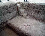 11d6009 |
| B1.Photo | 1998-7-15 | jW | L_V11d6009 |
| Notes on analogical record | 1998-7-15 | jW | view to the Southeast at the end of the excavation showing the perspective from the top, looking down into the square. [Input file: I715JLW.J / I715JLW.-J] |
| 1998-7-22 | jW | Final photo of the Southwestern corner at the end of the excavation. [Input file: V614CJC.J / V614CJC.-J] |

|
k1 |
| Template | 1998-7-25 | jLW.jpg | OH02t16 [Input file: I714JL.J / I714JL.-J |
| Orientation | 1998-7-14 | jL | looking south [Input file: I714JL.J / I714JL.-J] |
| Notes on analogical record | 1998-7-14 | gB | general view from the North - several takes from the ladder. OH2 in foreground, with tell in background; VWagen on slope from top of ridge; John behind VW to mark top of ridge; tent in depression; Mozan village on right simulates what ancient structures in OH2 would have looked like. In the last picture, Ismail's blue truck agiansgt wall of house indicates distance, since it is about as long as VW. [Input file: I714JLW.J / I714JLW.-J] |
| 1998-7-25 | jW | General view from the North. OH2 in the foreground, with tell in background; VW on slope from top of ridge; John behind VW to mark top of ridge; tent in depression; Mozan village on right simulates what ancient structures in OH2 would look like. Ismail’s truck against wall of dig house indicates distance, since it is about as long as VW [Input file: V614CJC.J / V614CJC.-J] |