Back to top: Excavation units
Unit
A unit is the maximal area of excavation. It is identified by a letter that correspond to the zone, and by a sequential number that matches the temporal progression of the excavations. Only exceptionally is a unit identified by a two letter code, which is otherwise reserved for areas. The only two letter code used so far for a unit is BH.
The unit label controls the indexing of every single element in the excavations. Thus any feature exposed in unit A1 will have the label A1f…, where the three dots stand for a sequential number from 1 to 9999. These are unique numbers that remain forever associated with that particular element, as its primary label.
Back to top: Excavation units
Digital book
All the data connected with a given excavation unit constitute a digital book by the same name. Unit books are the backbone of the whole system, because they contain the record in its globality. The challenge is for the system to transcend the “arbitrariness” inherent in the fact that a unit is by definition a fragment of a larger whole that does not necessarily have a typological identity of its own. This is the problem faced in dealing with the concept of a narrative.
Back to top: Excavation units
Physiognomy of a unit
Precisely because a unit is “arbitrary” in terms of its boundaries, which do not necessarily match those of the various typological realities discovered in the course of the excavation, it may seem to lack any marked sense of identity. In point of fact, however, each unit develops its own “physiognomy” which is of course related to the various typologies discovered, but is also defined by three other factors: the initial strategy reasons and expectations that determined the choice of the location; the history of the excavations; and the staff that has taken part in it.
The physiognomy of each unit grows during the excavation, and it reflects primarily the perception developed by the staff. For each unit,we make an attempt to capture this perception in the Overview section which is found at the beginning of each digital book.
Back to top: Excavation units
High Mound units
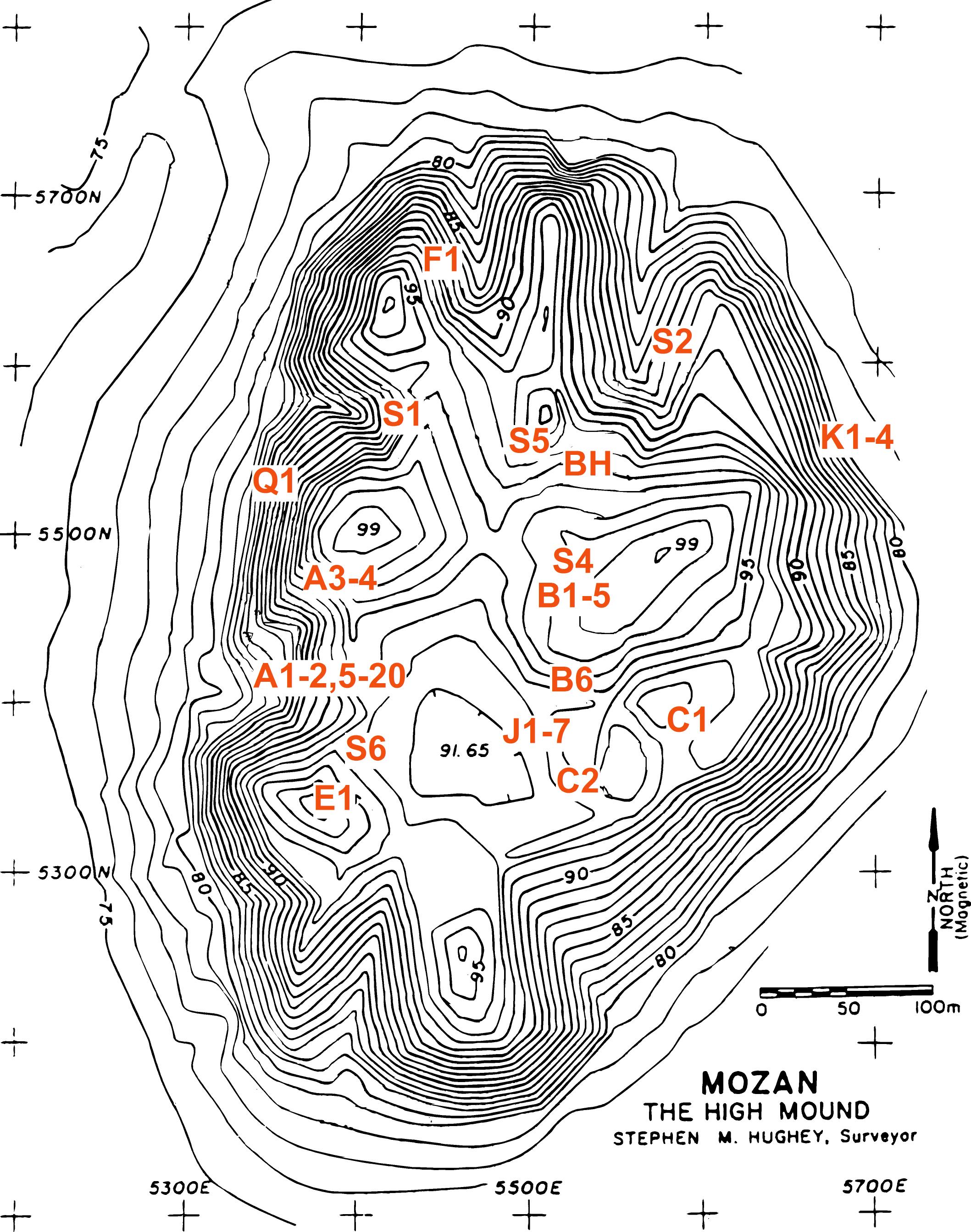
The following units have been opened on the High Mound since the beginning of the excavations (I do not give here a list of the units opened in the Outer City). I hope to be able eventually to develop a full Browser Edition for all these units. For now, the only units in a relatively advanced state of elaboration are the ones listed in the Urkesh Global Record section of the Urkesh website.
| A1-A2, A5-A20 | Palace (area AA) and strata above it, Lower Sacral Area |
| A3-A4 | top squares in step trench in Zone A |
| B1-B5 | Temple BA |
| B6 | trench sounding connecting BA with C2 (excavated by DOG team) |
| BH | Expedition House |
| C1 | ground truthing sounding |
| C2 | wide area excavated by DOG team |
| E1 | small superficial sounding for tent cables |
| F1 | residential or administrative building |
| J1-7 | Plaza and edge of Temple Terrace |
| K1-4 | inner city wall to the east |
| Q1 | small sounding to the west |
| S1 | long and shallow strip for the electrical cable |
| S2 | narrow, deep sounding for well |
| S4 | construction of test mudbrick wall in Temple area |
| S5 | construction of test stone wall in area of Expedition House |
| S6 | construction of path between Plaza and Palace |
 |
Back to top: Excavation units
Area A units
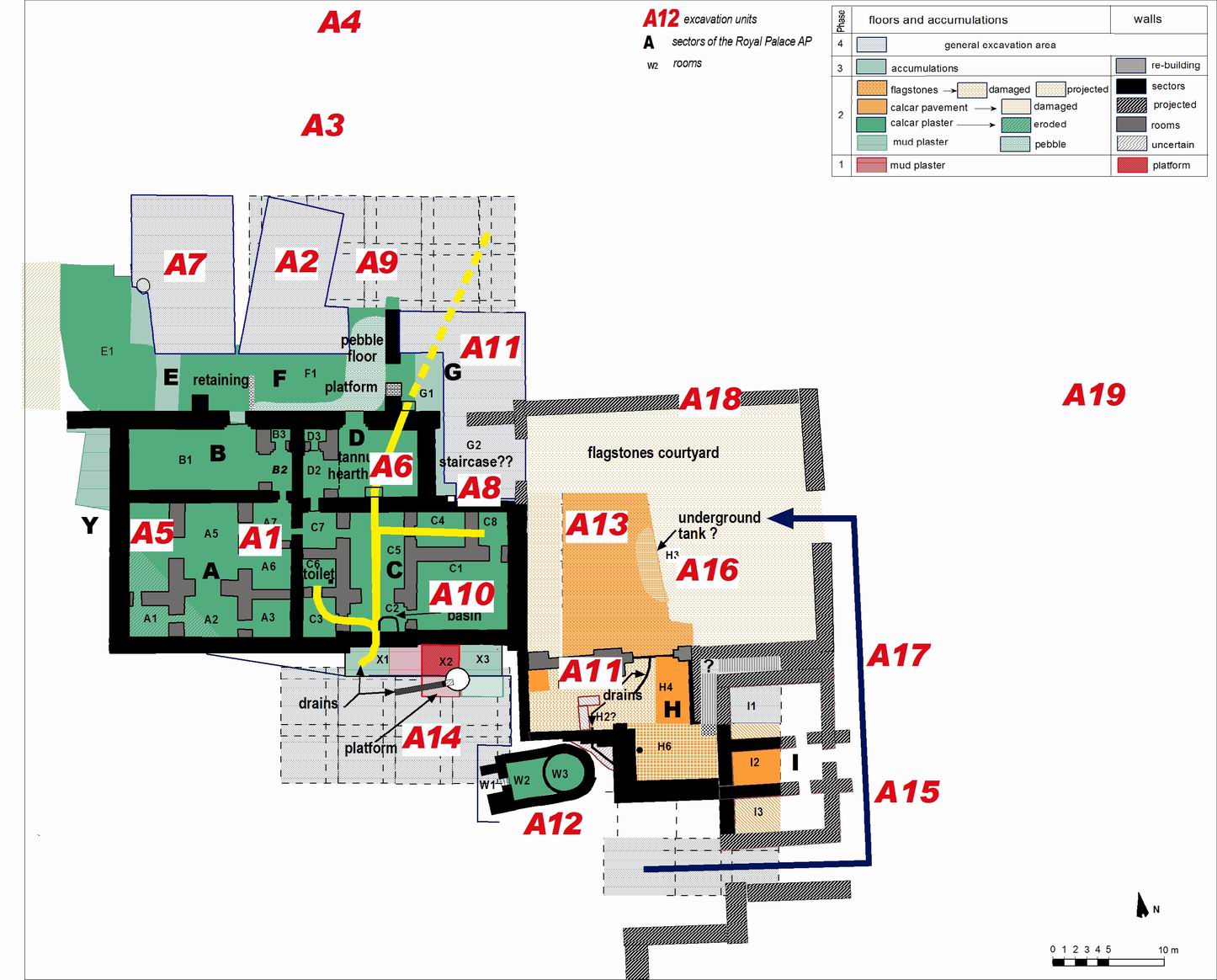
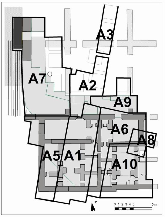
I give here a more detailed graphic overview of the units within Area A.


Back to top: Excavation units